Local Government
Melville
Region
Metropolitan
Canning Hwy Applecross and Como
Also is part of P3926 Raffles Hotel Precinct.
Canning Bridge northbound/downstream
MRWA No. 913
Melville
Metropolitan
Constructed from 1938
| Type | Status | Date | Documents |
|---|---|---|---|
| (no listings) |
| Type | Status | Date | Documents |
|---|---|---|---|
| (no listings) |
| Type | Status | Date | Grading/Management | |
|---|---|---|---|---|
| Category | ||||
| Art Deco Significant Bldg Survey | Completed | 30 Jun 1994 | ||
| Statewide Lge Timber Str Survey | Completed | 11 Dec 1998 | ||
16178 Canning Bridge
| Name | Type | Year From | Year To |
|---|---|---|---|
| E.W Godfrey, Public Works Department | Architect | - | - |
| Library Id | Title | Medium | Year Of Publication |
|---|---|---|---|
| 3174 | Western Roads : history of timber bridges in Western Australia. | Report | 1979 |
Historic site
| Epoch | General | Specific |
|---|---|---|
| Present Use | Transport\Communications | Road: Bridge |
| Original Use | Transport\Communications | Road: Bridge |
| Style |
|---|
| Other Style |
| General | Specific |
|---|---|
| TRANSPORT & COMMUNICATIONS | Road transport |
This information is provided voluntarily as a public service. The information provided is made available in good faith and is derived from sources believed to be reliable and accurate. However, the information is provided solely on the basis that readers will be responsible for making their own assessment of the matters discussed herein and are advised to verify all relevant representations, statements and information.
Canning Hwy Applecross and Como
Canning bridge westbound was assessed together with Canning Bridge eastbound, together as P16178 Canning Bridge. Is also part of P3926 Raffles Hotel Precinct.
Canning Bridge upstream
MRWA No. 912
South Perth
Metropolitan
Constructed from 1958
| Type | Status | Date | Documents |
|---|---|---|---|
| (no listings) |
| Type | Status | Date | Documents |
|---|---|---|---|
| (no listings) |
| Type | Status | Date | Grading/Management | |
|---|---|---|---|---|
| Category | ||||
| Statewide Lge Timber Str Survey | Completed | 11 Dec 1998 | ||
16178 Canning Bridge
| Library Id | Title | Medium | Year Of Publication |
|---|---|---|---|
| 6752 | South Perth : the vanishing village. | Book | 2003 |
Historic site
| Epoch | General | Specific |
|---|---|---|
| Original Use | Transport\Communications | Road: Bridge |
| Present Use | Transport\Communications | Road: Bridge |
| Type | General | Specific |
|---|---|---|
| Other | TIMBER | Other Timber |
| General | Specific |
|---|---|
| TRANSPORT & COMMUNICATIONS | Road transport |
This information is provided voluntarily as a public service. The information provided is made available in good faith and is derived from sources believed to be reliable and accurate. However, the information is provided solely on the basis that readers will be responsible for making their own assessment of the matters discussed herein and are advised to verify all relevant representations, statements and information.
Canning Hwy over the Canning River, between Applecross and Como Applecross and Como
Includes both bridges
Eastbound Downstream, ref 913
Westbound Upstream, ref 912
Melville
Metropolitan
Constructed from 1958, Constructed from 1937, Constructed from 1849 to 1869
| Type | Status | Date | Documents |
|---|---|---|---|
| Heritage List | Adopted | 16 Jun 2020 | |
| Heritage List | Adopted | 14 Nov 2000 | |
| State Register | Registered | 02 Mar 2012 | HCWebsite.Listing+ListingDocument, HCWebsite.Listing+ListingDocument |
| Type | Status | Date | Documents |
|---|---|---|---|
| (no listings) |
| Type | Status | Date | Grading/Management | |
|---|---|---|---|---|
| Category | ||||
| Municipal Inventory | Adopted | 17 Jun 2014 | Category A | |
Reports during the 1862 floods observed Canning Bridge being ‘gradually swept away’, with ‘only a portion of the centre remaining’ and the approaches completely lost.[1] However, less than three months later the bridge was reported as being ‘in a sufficient state of repair for all the purposes of ordinary traffic’.[2] In 1866, convicts were involved in repairs to both the bridge and its southern approaches.[3] Heritage documents in the 2000s claimed a replacement bridge was built by convicts in 1867, but searches of 1860s newspapers found no record of the bridge being replaced. Possibly works in 1869 to construct Upper Canning Bridge (Perth-Albany Road, Gosnells) have been confused with the Lower Canning site on the Perth-Fremantle Road.[4] Alternately, the ‘repairs’ of 1862 or 1866 may have been a complete reconstruction that was underreported. Canning Bridge was closed for some 18 months from early 1872 after a fire, rumoured to have been lit by fishermen, destroyed two central bays. The government offered £5 reward for information leading to conviction of those responsible. Winter floods caused further damage. The ‘reconstructed’ bridge reopened in 1873.[5] It is likely this ‘reconstruction’ was in later years remembered as a completely new bridge. The bridge that remained in 1892 (when a raised navigation span was added) was approximately 50ft longer than the one known to have been built in 1849,[6] supporting notions that it was not the original bridge (although, as the approaches were lost in the 1862 floods, it is possible that repairs included lengthening the bridge). As Fremantle Roads Board repeatedly invited tenders in 1872 and 1873 for the reconstruction work,[7] it is unlikely that convicts were involved. [1] Inquirer and Commercial News, 23 July 1862, p.4, https://trove.nla.gov.au/newspaper/article/69135805/6578395 [2] Perth Gazette and Independent Journal of Politics and News, 3 October 1862, p.3, https://trove.nla.gov.au/newspaper/article/2934069 [3] (no author), ‘Public Works’, Inquirer and Commercial News, 4 July 1866, p.3, https://trove.nla.gov.au/newspaper/article/69385749 [4] Perth Gazette and West Australian Times, 26 November 1869, p.2, https://trove.nla.gov.au/newspaper/article/3752009 (re Upper Canning Bridge under construction); Trove newspaper searches completed 5 & 6 November 2018 for ‘Canning Bridge’ and ‘tenders’ between 1862 and 1889; ‘Canning Bridge’ and ‘complete OR construct OR open’ between 1862 and 1869; ‘Canning Bridge’ (articles) in 1867; ‘Canning Bridge’ and ‘Public Works’ in 1868 (searching 163 WA newspapers) Report of recent and current public works in August 1867 mentions 40 bridges and does not include Canning Bridge (‘Public Works in the Colony’, Inquirer and Commercial News, 28 August 1867, p.2, https://trove.nla.gov.au/newspaper/article/69384127); Similar reports a year later 1868 also fail to mention any bridge on the Canning River or Perth-Fremantle Road Perth Gazette and West Australian Times, 14 August 1868, p.3, https://trove.nla.gov.au/newspaper/article/3753807) HCWA’s documentation for P16178 references the construction of a bridge in 1867 to a conference speech give in 2002 by Lloyd Margetts, engineer, of MRWA’s bridge section; South Perth Municipal Inventory place entry for the place (CB7) also references work by Margetts; Engineers Australia documents include direct input from Margetts, which is unreferenced (Engineers Australia WA Division Engineering Heritage Panel, Swan & Canning Rivers Bridges: Australian Engineering Week Tour 2012, Perth, July 2012, https://www.engineersaustralia.org.au/sites/default/files/content-files/2016-12/2012_heritage_bridges_tour_low_res.pdf [5] Kuon, ‘Percursory Papers’, Herald, 6 April 1872, p.3, https://trove.nla.gov.au/newspaper/article/111526212; ‘£5 Reward’ (advertisement), Herald, 25 May 1872, p.1, https://trove.nla.gov.au/newspaper/article/111527095; (no author), ‘Roads Boards: Fremantle’, Inquirer and Commercial News, 12 February 1873, p.4, https://trove.nla.gov.au/newspaper/article/65932858; Fremantle Roads Board, ‘Notice to the Public’, Inquirer and Commercial News, 23 July 1873, p.2, https://trove.nla.gov.au/newspaper/article/65933851 (quote ‘re-constructed’); Herald, 26 July 1873, p.3, https://trove.nla.gov.au/newspaper/article/114442667; [6] HCWA, P16178 Canning Bridge, Assessment Documentation, March 2012, p.5 [7] Eg Herald, 3 November 1872, p.2, https://trove.nla.gov.au/newspaper/article/114441332; (no author), ‘Roads Boards: Fremantle’, Inquirer and Commercial News, 4 December 1872, p.3, https://trove.nla.gov.au/newspaper/article/65933715
| Library Id | Title | Medium | Year Of Publication |
|---|---|---|---|
| 11995 | Report : Maintenance of Timber Bridges in the Metropolitian region. | Heritage Study {Other} | 2021 |
Historic site
| Epoch | General | Specific |
|---|---|---|
| Present Use | Transport\Communications | Road: Bridge |
| Original Use | Transport\Communications | Road: Bridge |
| Style |
|---|
| Other Style |
| Type | General | Specific |
|---|---|---|
| Other | METAL | Steel |
| Other | TIMBER | Other Timber |
| General | Specific |
|---|---|
| TRANSPORT & COMMUNICATIONS | Road transport |
This information is provided voluntarily as a public service. The information provided is made available in good faith and is derived from sources believed to be reliable and accurate. However, the information is provided solely on the basis that readers will be responsible for making their own assessment of the matters discussed herein and are advised to verify all relevant representations, statements and information.
Constructed from 1937, Constructed from 1999
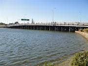
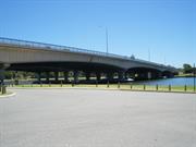
Canning Bridge, comprising two almost identical timber bridges, Canning Bridge eastbound (1937) and Canning Bridge westbound (1958), over the Canning River between Applecross and Como, has cultural heritage significance for the following reasons: The place is rare as an intact, substantial timber bridge comprising two adjacent structures built at different times; the site represents changing transport systems in Perth since 1829, from its origins as a ferry crossing, construction of the original Canning Bridge (1849), its role as part of the first road link between the city of Perth and the port of Fremantle through to construction of the current structures; the fishing platform underneath the 1958 structure is one of the few remaining of its kind; the place is valued as a site of recreational activities in the past to the present day, including organised sporting events, and as a venue for informal recreational activities; it achieved prominence in 1962, as the end point for rowing at the VII British Empire and Commonwealth Games; the place is an important landmark when viewed from the Swan and Canning Rivers, and the river foreshores. It contributes to the cultural landscape of the Applecross commercial precinct which includes Raffles Hotel (1937) and the distinctive façade of Applecross District Hall (1934); the place is a good example of a large timber bridge with cross braced driven piles, and demonstrates evidence of the innovative techniques of bridge conservation developed by the Main Roads Department in the 1970s. The signage on the bridges and the metal railings in the centre of the bridge have little significance.
Canning Bridge comprises two timber and steel framed bridges crossing the Canning River at Canning Highway connecting Melville and South Perth.
In summer, the Beeliar Nyoongars used the Canning River as a hunting ground as there was an abundant supply of food for them, and they used the land area around the Canning Bridge as a campsite. Initially, the site of the Canning Bridge was solely a ferry crossing at the narrowest point between the later settlements of Applecross and Como, close to the junction of the Canning and Swan Rivers. The first bridge across the river opened in 1843 to the design of Superintendent of Public Works, Henry Trigg, and constructed by Solomon Cook. A second replacement bridge was constructed in 1849 to increase the clearance beneath the 1843 bridge. In 1867 a new bridge was constructed with convict labour to increase traffic flow and address flood damage. Again, in 1908 and 1937 new bridges were constructed to replace the forerunners. In 1958, a new bridge was constructed solely for westbound traffic and the earlier 1937 bridge designated for eastbound traffic, to overcome the inadequacy of two-way traffic on a single bridge. Subsequently, concrete road overlays were introduced to both bridges in 1976 and 1984, and major repairs and maintenance was applied in 1994-96 and 1998-99.
Sound
| Ref ID No | Ref Name | Ref Source | Ref Date |
|---|---|---|---|
| "State Register of Heritage Places Assessment documentation for Place No. 16178 'Canning Bridge'". | HCWA | 2012 |
| Owner | Category |
|---|---|
| Main Roads WA | State Gov't |
This information is provided voluntarily as a public service. The information provided is made available in good faith and is derived from sources believed to be reliable and accurate. However, the information is provided solely on the basis that readers will be responsible for making their own assessment of the matters discussed herein and are advised to verify all relevant representations, statements and information.
Constructed from 1849
Canning Bridge, comprising two almost identical timber bridges, Canning Bridge eastbound (1937) and Canning Bridge westbound (1958), over the Canning River between Applecross and Como, has cultural heritage significance for the following reasons: • the place is rare as an intact, substantial timber bridge comprising two adjacent structures built at different times; • the site represents changing transport systems in Perth since 1829, from its origins as a ferry crossing, construction of the original Canning Bridge (1849), its role as part of the first road link between the city of Perth and the port of Fremantle through to construction of the current structures; • the fishing platform underneath the 1958 structure is one of the few remaining of its kind; • the place is valued as a site of recreational activities in the past to the present day, including organised sporting events, and as a venue for informal recreational activities. It achieved prominence in 1962, as the end point for rowing at the VII British Empire and Commonwealth Games; • the place is an important landmark when viewed from the Swan and Canning Rivers, and the river foreshores. It contributes to the cultural landscape of the Applecross commercial precinct which includes Raffles Hotel (1937) and the distinctive façade of Applecross District Hall (1934); and, • the place is a good example of a large timber bridge with cross braced driven piles, and demonstrates evidence of the innovative techniques of bridge conservation developed by the Main Roads Department in the 1970s. The signage on the bridges and the metal railings in the centre of the bridge have little significance.
Canning Bridge spans Canning River at the narrowest point where the River flows into the Swan River in Como and Applecross. The bridge consists of two adjacent timber structures designed and built by the Main Roads Department of Western Australia. The first structure, completed 1937, was designed and supervised by E. W. Godfrey, Chief Transport Engineer for Main Roads, and the second, almost identical, structure was completed 1958. Canning Bridge eastbound (1937) has a total length of 465 foot (141.8m), an overall width of 51’ 7” (15.7m) and an average clearance above normal water level of 19’ 8” (6.0m). It consists of 22 spans, typically 20 foot (6.1m) apart except for the central navigational span, which is 40 foot (12.2m) wide. The bridge is supported on timber piles. The piles have been potted at various locations and the majority have been epoxy wrapped at water level. The deck consists of three traffic lanes 37’ 5” (11.4m) wide and a footpath. Canning Bridge westbound (1958) has an overall length of 474 foot (144.6m), a width of 45 foot (13.7m) and a clearance of 19’ 8” (6.0m) above normal water level. It consists of 22 spans, typically 20 foot (6.1m) apart except for the navigational span, which is 40 foot (12.2m). The bridge is supported on timber piles, typically eight per span except for the navigational span, which has 12 piles. The deck of the bridge consists of three traffic lanes 37’ 4” (11.4m) wide and a 4’ 11” (1.5m) wide footpath. The timber pylons on both bridges are inscribed with roman numerals. Both bridges are sealed in hot mix asphalt on the vehicular traffic lanes and the footpaths are timber decking overlaid with concrete. The bridges carry water and electrical services. Steel conduits for street lighting are located on the base of the guardrail on the right hand side of the footpath on the downstream (1937) bridge. A similar steel conduit is attached to the half caps adjacent to the left hand side of the footpath posts on the Canning Bridge westbound (1958). The building of the fishing platform on Canning Bridge westbound (1958) emulates the platform on the third Canning Bridge built in 1908, which was specifically designated for fishing. It is now designated as a maintenance platform reached by a timber gangplank that adjoins the shoreline under the bridge. The area around Canning Bridge has seen continual development since the 1960s. As a result Canning Bridge is an important landmark with arteries leading off north and south into the Kwinana Freeway, east and west to the Canning Highway and east to Manning Road. The construction of Canning Bridge station in December 2007 for the Perth to Mandurah rail line has further impacted and changed the surrounding environment. The area around the bridge exhibits a mixture of land uses including wetlands, urban infrastructure and recreation. On the Como side of Canning Bridge between the Kwinana Freeway and the river there are no built elements. The vegetation consists of grassed riverbanks and re-established areas of native flora including Salt sheoak (Casuarina obesa), Geraldton wax (Chamelacium uncinatumm) Pencil pines (Cupressus) and a number of wattle and banksia species.
The first bridge over the Canning River was designed by the Superintendent of Public Works, Henry Trigg, who advertised for building tenders in the Perth Gazette on 26 December 1846. The original tenders for the bridge were too high so the project did not advance. In 1849 tenders were recalled and the contract was awarded to Solomon Cook. Cook completed the bridge in four months at a cost of £425. The bridge was 520 feet (175 metres) long, 12 feet (4 metres) wide and had a deck eight feet (2 metres) above the water. The central span of the bridge was 24 feet (8 metres) wide to allow boats to pass underneath.1 The bridge was an important part of road communication between Guildford, Perth and Fremantle even though for a number of years the river remained the main method of transportation of goods between the inland reaches and the coastal port. In 1862 widespread flooding throughout the Swan and Canning Rivers led to massive damage to the Canning, Causeway and Helena (in Guildford) bridges. Owing to the damage, a second Canning Bridge was built in 1867 using convict labour. It is thought the site of the second Canning Bridge was very close to the present bridge. Canning Bridge No. 2 was built 12 feet (4 metres) above the water but was raised in 1892 to 18 feet (6 metres) to allow for increased navigational clearance. Maintenance of the Canning Bridge and the road that linked Perth to Fremantle was given a low priority in the late nineteenth and early twentieth centuries, leading to a deterioration of structure. According to one report from the time, a fire had caused bad damage and a replacement bridge was sought. Owing to the critical nature of the bridge, the State Government allocated funding for a new bridge in 1907-08. Canning Bridge No. 3 was constructed in 1908 and was located south east of the bridge that is currently used (2003). Flatter in appearance and stronger in construction, the new bridge was built under contract for the cost of £2,023. At this time a fishing platform was added to the bridge. Despite the stronger construction, the 1908 bridge was replaced by a new bridge which was commenced in 1937. Built by the Main Roads Department at a cost of £24,830 Canning Bridge No. 4 was constructed with a number of essential services such as water and gas mains and electricity installed under the roadway. The navigation openings included two of 24m wide and one of 18m wide. The bridge was constructed of karri, jarrah and wandoo owing to their abundance and resistance to fire and dry rot. To protect the timber piles from marine borers, concrete collars were put in place. Enhancing the appearance of the bridge were four ornamental concrete pylons surmounted with lanterns cast in bronze and placed at the entrances. Canning Bridge No.4 was officially opened on December 1939 by the Minister of Works, H. Millington MLA. The opening was celebrated by a small gathering of Main Roads people at the Swan Hotel. The old bridge which was going to be demolished had a reprieve owing to the outbreak of World War Two. Owing to the fear of invasion, the old bridge was kept in case of possible damage to the new bridge by an enemy attack. The old bridge was therefore not demolished until the late 1940s. Since then there have been various maintenance and renovation programs. In 1976 a reinforced concrete overlay was placed on the bridge deck and in 1994-5 termite damage led to karri timber being replaced by steel. In 1998-99 superstructure damage was arrested by reinforced concrete treatment. The Canning Bridge remains a vital link between South Perth and Fremantle.
High
Good
| Name | Type | Year From | Year To |
|---|---|---|---|
| Henry Trigg | Architect | - | - |
| Ref ID No | Ref Name | Ref Source | Ref Date |
|---|---|---|---|
| Edmonds, L. "The Vital Link: A History of Main Roads of WA 1926-1996" | UWA Press | 1997 | |
| Florey, C. "Peninsular City: A Social History of South Perth" | City of South Perth | 1995 | |
| Le Page, J.S.H. "Building a State: The Story of the Public Works Department WA 1829-1985" | |||
| Margetts, L. Article 'The Bridges of South Perth' | South Perth- The Vanishing Village (Published by South perth Historical Society) | 2002 |
| Reserve | Lot/Location | Plan/Diagram | Vol/Folio |
|---|---|---|---|
| 12508 | 219118 | 3119-153 |
This information is provided voluntarily as a public service. The information provided is made available in good faith and is derived from sources believed to be reliable and accurate. However, the information is provided solely on the basis that readers will be responsible for making their own assessment of the matters discussed herein and are advised to verify all relevant representations, statements and information.
111 Melville Pde Como
Gordon's Tea Rooms, Stardust Room
Pagoda Long Bar & Restuarant
South Perth
Metropolitan
Constructed from 1926 to 1998
| Type | Status | Date | Documents |
|---|---|---|---|
| Heritage List | Adopted | 14 Nov 2000 | |
| State Register | Registered | 13 May 2005 | HCWebsite.Listing+ListingDocument, HCWebsite.Listing+ListingDocument |
| Type | Status | Date | Documents |
|---|---|---|---|
| (no listings) |
| Type | Status | Date | Grading/Management | |
|---|---|---|---|---|
| Category | ||||
| (no listings) | ||||
Pagoda, Como is in good condition and has been well maintained. Repairs and alterations have been carried with reasonable sensitivity to the original building style.
| Name | Type | Year From | Year To |
|---|---|---|---|
| Harold Gordon | Architect | - | - |
| Library Id | Title | Medium | Year Of Publication |
|---|---|---|---|
| 6752 | South Perth : the vanishing village. | Book | 2003 |
Individual Building or Group
| Epoch | General | Specific |
|---|---|---|
| Original Use | COMMERCIAL | Restaurant |
| Other Use | SOCIAL\RECREATIONAL | Other |
| Present Use | COMMERCIAL | Restaurant |
| Style |
|---|
| Other Style |
| Type | General | Specific |
|---|---|---|
| Roof | TILE | Terracotta Tile |
| Wall | BRICK | Common Brick |
| Other | TIMBER | Other Timber |
| General | Specific |
|---|---|
| OCCUPATIONS | Commercial & service industries |
| OCCUPATIONS | Hospitality industry & tourism |
| SOCIAL & CIVIC ACTIVITIES | Sport, recreation & entertainment |
This information is provided voluntarily as a public service. The information provided is made available in good faith and is derived from sources believed to be reliable and accurate. However, the information is provided solely on the basis that readers will be responsible for making their own assessment of the matters discussed herein and are advised to verify all relevant representations, statements and information.
Constructed from 1922 to 1926
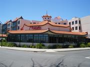
The following statement is drawn from the State Register Entry for Place 2403 Pagoda, Como, prepared in 2004. Pagoda, Como, a masonry and tile building with an octagonal plan and distinctive three-tiered terracotta tiled roof, constructed in 1926 and largely reconstructed in 1998, has cultural heritage significance for the following reasons: • the place is a unique example of recreational architecture in Western Australia, with Chinese inspired details and form, including an • octagonal tower and a three tiered roof that turns up at the edges and is adorned with decorative ridge accents, gargoyles and a finial; • the place contributes to a sense of place for residents and visitors to Perth as a well-known social venue and prominent landmark and is • valued by the community for its continued recreational and social functions for over seventy years; and, • the place is rare as the only extant example of the buildings constructed for leisure, recreational and entertainment purposes at • Como Beach at the height of its popularity as a summer resort during the 1920s, which lasted to some degree until the Kwinana Freeway was built in 1959.
The Pagoda Ballroom is a single storey building of octagonal plan form with a distinctive three-tiered terracotta tiled roof. The place is located on a prominent corner position at the western end of Comer Street at its intersection with Melville Parade and has a more recent multi-storey hotel development built to the rear and north but the Pagoda still retains prominence in the street view and in longer views from the freeway. The building is of single storey rendered masonry and tile construction with Chinese inspired details and form. The distinctive three-tiered bellcast roof turns up at the edges and is adorned with decorative ridge accents, gargoyles and finials. The place has an octagonal plan, presenting with five of the eight faces to the street. The rear three faces are connected to the more recent development behind. Each of the visible faces of the building are divided into three bays and the majority of these present with continuous band of multi-paned timber framed windows above a masonry wall. The remaining visible face has three fully rendered bays. The second and third tiers of the roof are clad with fibrous sheeting with the top level incorporating porthole windows. The entrance is located on the northern face, through double doors which has a strong relationship with the adjoining hotel development. There are no doors that open out to Melville Parade or Comer Street. The café blinds that have been installed to the western faces creates a blank aesthetic to the most visible aspects of the building
The following information is largely drawn from the Heritage Council of WA Assessment prepared in 2005. In 1892, the South Perth Roads Board was established and, in 1902, the suburb became a municipality. By the turn of the century, there were four jetties at South Perth, the Zoological Gardens had opened in 1898, and a government school and postal facilities were established. Due to its relative isolation from Perth, the South Perth area was regarded as a retreat from the city, a place of popular recreation, social and leisure facilities. By the beginning of the twentieth century, land south of the Zoological Gardens began to attract the attention of land developers and home buyers. The area in which Pagoda, Como is situated was originally part of the 533 acres comprising Swan Location 40, the Como Estate, owned by Mark Gardner, a Perth produce merchant. In 1906, the developer of the Como Estate arranged the building of the Como Jetty, with all the timber hauled from the Canning Road. From 1907, the South Perth Municipal Council passed resolutions aimed at improving the Como area. In the following years many public events were held to promote the area and improved camping facilities were provided for holidaymakers. It was during the 1920s that a string of tea rooms, dance pavilions and lodging houses were constructed along the foreshore shell track of Melville Terrace (now Melville Parade), all the way to the Canning Bridge. According to one account, at least seventeen tea rooms operated along and around Como Beach. Circa 1922, Harold C. Gordon began operating a boarding-house and a ‘SPOT Lager Saloon’ on the corner of Comer Street and Melville Terrace in Como. In the following year, the Post Office Directory also listed a tea room operating from this site, but no ‘saloon’. Gordon’s establishment provided accommodation for about twenty people in a large house, from where the tea rooms also operated. Gordon’s rooms were further divided over summer in order to fit in as many paying customers as possible. According to Rate Book entries, the Pagoda was built in 1926, immediately to the west of the existing boarding-house. Its octagonal structure, in a pseudo-Chinese style, would have made it a well-known landmark in the local area. By 1927, the Pagoda and Gordon’s original boarding-house was sold to Alexander McAllister Clydesdale, and re-opened as a roller skating rink in 1928, but this venture also failed shortly after this time. In the summer of 1929, the Pagoda operated as tea rooms and a ‘dance pavilion’ again, for a short period, under the management of K.A. Boskas, but small attendances made this operation unprofitable. The economic viability of the Pagoda in the 1920s, and the other similar businesses in the Como Beach area, was adversely affected both by the seasonal nature of their operations as well as by the lack of frequency of public transport to the area. With the depression of the first half of the 1930s, tea rooms and other businesses at Como Beach struggled to remain economically viable. During the decade from 1930, the Pagoda, now owned in partnership by Alexander Clydesdale and Frank Stiles, continued to operate as a roller skating rink, although it seems also to have been used on occasion for social functions. Between 1942 and 1945, the ownership of Pagoda, Como was transferred to Mr and Mrs J.P. and E.V. Pell. In 1945, the Pagoda was requisitioned for war-time use as a billet for soldiers. After the War, the Pagoda reverted to operation as a dance hall and reception centre. Minor structural changes to Pagoda, Como were carried out in 1947 and 1950. From the late 1950s until the early 1990s, the Pagoda continued to be used as a dance hall and as a reception centre. By 1970, the original tea rooms and dance hall building had all its ground floor glazing replaced by timber boards. Some time between 1969 and 1978, the original (pre-1926) Gordon’s Tea Rooms and boarding house, immediately to the west of the Pagoda was demolished. In 1995, the Kareelya Property Group, engaged architects Overman and Zuideveld to look at the development potential of the property. The City of South Perth subsequently approved a 101 room holiday resort, with the original 1926 Pagoda Tea Rooms building to be incorporated into the development as a bar area with considerable conservation and restoration work, while the later ball room addition of the 1950s was to be demolished. The redeveloped building and adjoining hotel complex was opened in 1998 and continues to be used as a bar and restaurant.
Moderate - Low
Good
| Name | Type | Year From | Year To |
|---|---|---|---|
| Harold Gordon | Architect | - | - |
| Reserve | Lot/Location | Plan/Diagram | Vol/Folio |
|---|---|---|---|
| Strata Lot 1 on Lot 103 | 90368 | 2715-464 |
| Owner | Category |
|---|---|
| Grangefield Pty Ltd | Other Private |
This information is provided voluntarily as a public service. The information provided is made available in good faith and is derived from sources believed to be reliable and accurate. However, the information is provided solely on the basis that readers will be responsible for making their own assessment of the matters discussed herein and are advised to verify all relevant representations, statements and information.
16 Preston St Como
2/11/2011 Address includes 16, 16A & 16B Preson St, Como. VFL.
Como Theatre
Cygnet Cinema
South Perth
Metropolitan
Constructed from 1938
| Type | Status | Date | Documents |
|---|---|---|---|
| Heritage List | Adopted | 14 Nov 2000 | |
| State Register | Registered | 30 Jun 1995 | HCWebsite.Listing+ListingDocument, HCWebsite.Listing+ListingDocument |
| Type | Status | Date | Documents |
|---|---|---|---|
| (no listings) |
| Type | Status | Date | Grading/Management | |
|---|---|---|---|---|
| Category | ||||
| Art Deco Significant Bldg Survey | Completed | |||
| Register of the National Estate | Registered | 27 Oct 1980 | ||
| Register of the National Estate | Interim | 24 Jun 1997 | ||
| Classified by the National Trust | Classified | 02 May 1988 | ||
| Name | Type | Year From | Year To |
|---|---|---|---|
| William Leighton | Architect | - | - |
| Library Id | Title | Medium | Year Of Publication |
|---|---|---|---|
| 7921 | Cygnet cinema (former Como theatre) : conservation plan. | Heritage Study {Cons'n Plan} | 2006 |
| 11459 | Picture Palaces of the Golden West | Book | 2016 |
| 11668 | Cygnet Cinema (formerly The Como Theatre) | Heritage Study {Cons'n Plan} | 2018 |
Individual Building or Group
| Epoch | General | Specific |
|---|---|---|
| Present Use | SOCIAL\RECREATIONAL | Theatre or Cinema |
| Original Use | SOCIAL\RECREATIONAL | Theatre or Cinema |
| Style |
|---|
| Inter-War Functionalist |
| Type | General | Specific |
|---|---|---|
| Wall | BRICK | Rendered Brick |
| Roof | ASBESTOS | Fibrous Cement, corrugated |
| General | Specific |
|---|---|
| SOCIAL & CIVIC ACTIVITIES | Sport, recreation & entertainment |
This information is provided voluntarily as a public service. The information provided is made available in good faith and is derived from sources believed to be reliable and accurate. However, the information is provided solely on the basis that readers will be responsible for making their own assessment of the matters discussed herein and are advised to verify all relevant representations, statements and information.
Constructed from 1938
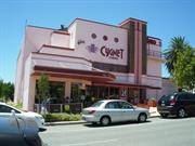
The following statement is taken from the Register Entry for Place 2404 Cygnet Cinema prepared by the State Heritage Office in 1994. Cygnet Cinema has cultural heritage significance for the following reasons: • the place is a demonstration of the new functional approach to cinema design in Perth in the late 1930s. The combination of one projection unit for both indoor auditorium and outdoor picture garden was an innovation of the period; • the place is a fine example of the Inter-War Functionalist style; • apart from being the first purpose-built sound cinema in the suburbs immediately south of the city, the place is rare as the least altered of the 1930s suburban cinemas of Perth that are in operation; • the place is closely associated with Western Australian cinema pioneer James Stiles, and cinema architect William Leighton; • the siting and distinctive form of the place has established Cygnet Cinema as a Como landmark; and • the place is valued and continues to be used by the community as a place of cinema entertainment
Cygnet Theatre is a two storey structure, built originally with an adjoining outdoor picture garden. It is of load bearing brickwork with low pitched roof corrugated roof which is obscured from view. Much of the brickwork has been rendered which provided a contrast with the face brickwork and latterly, additional sections of face brickwork have also been painted. The distinctive tower remains unpainted contrasting with the decorative central fluted strip. Due to the lack of alteration to the building form, the central tower still remains a prominent feature of the building. As was typical with buildings of the Inter-War Functionalist style, the Cygnet Theatre incorporates simple geometric shapes of stark angles and smooth curves. Windows to the façade are arranged as a horizontal band of metal framed openings, with three porthole openings in the rendered section above. The entrance to the theatre is by way of three sets of timber framed glass double doors. The Cygnet Theatre is of asymmetric plan form to the façade with a range of projecting elements at first floor level and a single storey chamfered edge coffee shop to the south west corner of the façade, projecting out beyond the building line of the theatre. The tower marks the transition from sharp angles to the prominent curved wall, with steel railings around the external walkway to the upper level. Generally the building still reflects its original design intent although changes have occurred. The building was originally named “Como Theatre” the name of which still remains around the top of the curved wall in bas relief art deco style lettering. Additional signage used to be mounted on top of the tower and down the length of the tower, the mounting holes can still be seen. Since being renamed the Cygnet Cinema, the name has been painted on the rendered surface below the porthole openings. There is evidence of a blocked up opening at ground level in the curved wall.
The following information is largely drawn from the Heritage Council of Western Australia Assessment document prepared in for the inclusion of Cygnet Cinema in the State Register of Heritage Places in 1994. During the 1930s, South Perth and adjacent suburbs were residential areas surrounded by the Swan River, with stretches of river beaches. It was largely a family-orientated, 'respectable' area. Como Beach was very much a family area, with its shallow waters suitable for young families. A ferry service to the city left from the Como Jetty, at the bottom end of Preston Street. The 1930s, was a boom period for entertainment. Throughout Australia a visit to the cinema was a popular pastime, an inexpensive escape from the economic depression. The novelty of the sound revolution in cinema attracted many more film-goers and this increased popularity was reflected in the number of cinemas either built or altered to specifically accommodate 'talkies'. The expansion of cinema entertainment was not confined to the traditional city centres of Perth or Fremantle. Many cinemas were built in the suburbs. Suburban cinemas not only serviced local patrons, but brought patrons in from surrounding suburbs. The ferry service to Como Jetty ran between Perth, Coode Street, Como and Canning Bridge. The tram service ran from Canning Highway to Angelo Street, with an extension along Labouchere Road to Preston, Mary and Ednah Streets. Como Theatre was not the first cinema in the South Perth area. In 1922, Swan Street Hall screened pictures twice weekly. Gaiety Picture Theatre, situated on the corner of Coode and Angelo Streets, was built for James Stiles and C. R. Clydesdale in 1926. The Stiles family came to South Perth in the late 19th century. Arabella Stiles operated the Tea Gardens Hotel in Suburban Road, and her sons James and Arthur were involved in the early development of South Perth. James became an estate agent, and for five years was Assistant Town Clerk in the South Perth Road Board. Hurlingham Picture Theatre on Canning Highway was an open-air theatre built for James Stiles in 1933. Both Gaiety Picture Theatre and Hurlingham Picture Theatre were in operation when in 1938, Stiles managed to secure a ten year lease on Piccadilly Theatre, modernised his existing cinemas and built Como Theatre. Como Theatre was designed by architect, William Leighton of Baxter Cox and Leighton. In the late 1930sLeighton earned his reputation as a leading cinema designer for his work on several Perth cinemas, including Piccadilly Theatre and Arcade, Windsor Theatre, and Astor Theatre, as well as the refurbishment of Royal Theatre and Grand Theatre. Como Theatre was officially opened on 4 March 1938, by the chairman of the South Perth Road Board, G.V. Abjornson. The emphasis of Leighton’s cinema architecture of the 1930s, was that of designing functional contemporary buildings, and his cinemas commonly featured streamlined symbols and motifs for decoration. Como Theatre reflects the architectural style popular in the inter-war period, using nautical motifs such as wavy lines, smooth flat curves and tubular handrails, with an architectural emphasis on both the horizontal and the vertical aspects of the building. The plaster motifs used in Como Theatre were modelled by Edward Kohler, who worked for the Perth Modelling Works. Como Theatre originally had both an indoor auditorium and an outdoor picture garden. The concept of servicing an indoor and outdoor cinema by the one mechanised 'bio box' was first introduced by Leighton in the design of the Windsor Theatre in Nedlands, completed six months before the Como Theatre. James Stiles died of a heart attack in 1944. The Stiles family retained ownership interests in the South Perth and Perth movie scene, with James's nephew, Arthur, after World War II. The cinemas continued to prosper in the 1940s and 50s. However, business declined in the 1960s. The Como Theatre opened once a week except during summer when, from 1964 to 1968, it ran Festival of Perth films. It was through the association with the Festival of Perth that in 1968 Como Theatre was renamed Cygnet Cinema, to associate the cinema with the Festival of Perth, the logo of which is a swan. Despite the name change, the original Broadway face type lettering stating 'The Como Theatre' around the 'bio box' still exists. With strong and increasing competition posed by the popularity of home televisions, air conditioning was installed in the Theatre in October 1968, but patronage continued to drop and the picture garden was demolished the following year. In 1981, alterations were made to the auditorium. In 2005, the Cygnet Theatre received a $4,500 heritage grant from the State Government. In 2010, $20 million plans for the adaptive reuse and modification of the existing Cygnet Theatre were investigated but did not proceed. In 2013, the Cygnet Theatre received a $100,000 heritage grant from the State Government. This allowed the upgrading of wiring and fire prevention systems and the installation of a digital projector to replace the use of 35mm film reels, enabling the Theatre to remain viable. In 2018, the place still operates as a cinema as one of the venues for a large national cinema chains.
High
Good
| Name | Type | Year From | Year To |
|---|---|---|---|
| William Leighton | Architect | - | - |
| Ref ID No | Ref Name | Ref Source | Ref Date |
|---|---|---|---|
| Assessment documentation for Place 2396 Cygnet Cinema |
| Reserve | Lot/Location | Plan/Diagram | Vol/Folio |
|---|---|---|---|
| Lots 1, 2, 3 | 5661 | 51-139A |
| Owner | Category |
|---|---|
| James Stiles | Other Private |
This information is provided voluntarily as a public service. The information provided is made available in good faith and is derived from sources believed to be reliable and accurate. However, the information is provided solely on the basis that readers will be responsible for making their own assessment of the matters discussed herein and are advised to verify all relevant representations, statements and information.
Perth & South Perth
Bridge No 953
South Perth
Metropolitan
Constructed from 1959
| Type | Status | Date | Documents |
|---|---|---|---|
| Heritage List | Adopted | 25 Sep 2018 | |
| State Register | Registered | 23 Apr 1999 | HCWebsite.Listing+ListingDocument, HCWebsite.Listing+ListingDocument |
| Type | Status | Date | Documents |
|---|---|---|---|
| (no listings) |
| Type | Status | Date | Grading/Management | |
|---|---|---|---|---|
| Category | ||||
| Local Heritage Survey | Adopted | 13 Mar 2001 | Category A | |
| Perth Draft Inventory 99-01 | YES | 31 Dec 1999 | ||
| Name | Type | Year From | Year To |
|---|---|---|---|
| Sir W Holford & Partners, UK | Architect | - | - |
| Library Id | Title | Medium | Year Of Publication |
|---|---|---|---|
| 6752 | South Perth : the vanishing village. | Book | 2003 |
| 8788 | New MetroRail : southern suburbs railway. Operations noise and vibration management plan Narrows Bridge to Perth Rail Yard. DRAFT for stakeholder comment. | Report | 2007 |
| 7759 | Guide to heritage bridge management. | Book | 2001 |
| 8711 | From the wastelands. | Journal article | 2001 |
| 9212 | Mitchell Freeway Stage 1: National engineering landmark award unveiling ceremony. | Brochure | 2008 |
| 4899 | Narrows Bridge : conservation plan. | Heritage Study {Cons'n Plan} | 1998 |
Historic site
| Epoch | General | Specific |
|---|---|---|
| Original Use | Transport\Communications | Road: Bridge |
| Present Use | Transport\Communications | Road: Bridge |
| Style |
|---|
| Other Style |
| Type | General | Specific |
|---|---|---|
| Wall | CONCRETE | Reinforced Concrete |
| General | Specific |
|---|---|
| TRANSPORT & COMMUNICATIONS | Road transport |
This information is provided voluntarily as a public service. The information provided is made available in good faith and is derived from sources believed to be reliable and accurate. However, the information is provided solely on the basis that readers will be responsible for making their own assessment of the matters discussed herein and are advised to verify all relevant representations, statements and information.
Constructed from 1959
The following statement is drawn from the State Register Entry for Place 4795 narrows Bridge, prepared in 1999. (It does not include reference to the railway line or second bridge built in 2001) Narrows Bridge, a five span pre-stressed concrete bridge, has cultural heritage significance for the following reasons: • the place is a strong landmark element of the visual landscape which comprises the built form of the City and the Narrows Bridge and the natural form of the river and Mt Eliza, this same visual resolution is apparent during the day and at night time in the context of an illuminated City and Bridge; • the place is the first physical manifestation of the Hepburn and Stephenson plan, which contributed to the development of the Freeway road systems in the State and the Perth Metropolitan Region Scheme from the 1950s; • the pre-stressed concrete structure is representative of innovative engineering technology and method developed in the 1950s. The construction involved structural design, techniques and materials appropriate to a low-profile structure in a visually, critical location with difficult foundation characteristics; • the place has associations with eminent consulting engineers, Maunsell & Partners in the U.K. and consulting architects, Sir William Holford and Partners in the U.K., as an element of the Stephenson-Hepburn Report of the 1950s which emphasised the need for aesthetic consideration to be incorporated into the design of the Bridge; and, • the place contributes to the community's sense of place as an element in the landscape of the City.
The Narrows Bridge comprises three separate structures which appear to form one single bridge. The original road bridge (1959) is the eastern span which provided six lane vehicle access and pedestrian walkways either side. The western section (2001) was constructed six metres to the west of the original section and is of similar pre-cast concrete construction. The central section comprises the railway bridge which was constructed in 2007. The three separate structures are evident from underneath with narrow slithers of light filtering through either side of the railway bridge. From above, the bridge provides a more unified picture and creates the appearance of a single structure. The original 335 metre long pre-stressed concrete road bridge, said to be the largest of its type in the world when it was constructed, is built on hollow steel cylinders filled with reinforced concrete and driven about 34 metres below the river’s surface. The original six-lane Narrows Bridge, on foundations sunk into reclaimed mud flats, is fixed at its northern end and rolls on ball bearings at its southern end to cope with expansion. The construction involved innovative engineering technology at the time, and utilised structural design, techniques and materials appropriate to a structure required to be low-profile in a visually critical location, with difficult foundation characteristics. The second road bridge, constructed in 2001, closely follows the design of the original bridge. The railway bridge, centred between the two road bridges, is almost undiscernible from a distance, apart from some vertical infrastructure at intervals along the bridge. At night, the bridges are illuminated, making the Narrows Bridge a prominent landmark at all times. Due to its prominent position across the Swan River, the Narrows Bridge is a strong landmark element of the landscape in views along Mounts Bay Road and Riverside Drive to the north of the River and South Perth Esplanade to the south of the river.
This information is largely drawn from the Heritage Council of WA Assessment prepared in July 1998. The Narrows Bridge was built in 1959. Discussions about how to bridge the narrow neck in the river, known as ‘the Narrows’, between Perth Water and Melville Water, first took place in the 1840s. However, priority was given to a causeway to the east of the Perth CBD, which was opened to traffic in May 1843. The first means of crossing from Point Belches to the foot of Mt Eliza, the closest point, was via a pole punt carrying horses, riders and cargo from 1833. Throughout the first half of the 20th century, the issue of a bridge across the Narrows caused division within both the South Perth Council and the community. Local residents objected on the grounds that it would spoil the view to and from the city. Direct road access to South Perth from the CBD was favoured by land and property developers, but was resisted by those who wanted South Perth to retain its quiet residential character although many of the South Perth residents were daily commuters between the peninsula and the City of Perth. The ferry and tram system was a constant source of dissatisfaction among the commuters. By 1935, a Road Board publication referred to the bridge as inevitable and from about 1952 onward, the pressure for a bridge became really intense. Largely as a result of the Stephenson-Hepburn Report released in 1955, a decision was made at State Government level to proceed with the construction of a bridge. In 1955, eminent consulting engineers, Maunsell and Partners of London and Melbourne, were appointed consulting engineers. Also involved were consulting architects, Sir William Holford and partners in the UK. In March 1957 a tender of £1,700,000 ($3,400,000) was accepted from Christiani and Nielson, in association with J O Clough & Son (Pty) Ltd of Perth. Construction of the bridge began in 1956 and involved reshaping Point Belches and taking about 200 feet (61 metres) off the shoreline, reclaiming a controversially large extent of Perth Water and changing the character of the view of Perth from Mt Eliza. At one stage, the name of the new bridge was to be the ‘Golden West Bridge’, but this decision was later reversed, and the Narrows Bridge was officially opened on Friday 13 November 1959. The Narrows Bridge included entry and exit ramps at South Perth near the tip of the peninsula. Initially, the entry from South Perth onto the freeway was in the form of a loop road under the Bridge via South Perth Esplanade; and the exit from the freeway into South Perth was a simple ramp that connected to the northern end of Mill Point Road. However, by 1967, congestion caused traffic movements to be re-examined. The local roads were modified to close the original entry ramp and create new north- and south-bound entry ramps and a south-bound exit ramp at Judd Street, while also modifying the north-bound exit ramp at the tip of the peninsula. From the 1970s, owing to an increase in traffic volumes and congestion across the bridge, plans were floated for a second bridge alongside the original Narrows Bridge. A decision to build a second bridge was approved in 1998 and work began by Leighton Contractors on the duplicate bridge in May 1999. The new bridge is situated 6 metres west of the original bridge. In October 2001, the second road bridge replicating the design of the first, opened alongside the original Narrows Bridge. The new bridge was designed to carry north-bound traffic, doubling the capacity of the original 3 x 3 lane bridge and including a dedicated bus lane on each bridge. The construction was achieved without the need to widen the existing freeway reserve, or undertake further reclamation of the river. Considerable renovations to the original bridge were also undertaken as part of this work. In 2005, further construction work commenced on the dual Narrows Bridge to accommodate a two-way railway line. This was part of a new railway line located between the opposing traffic lanes of the Kwinana Freeway; and extending from the Perth central business district to Mandurah. The work on both bridges was completed in 2007, accommodating south-bound lines on a new railway bridge constructed in the 6.0 metre gap between the two road bridges. The north-bound tracks are laid on the north-bound (western) road bridge which opened in 2001.
High / High
Good
| Name | Type | Year From | Year To |
|---|---|---|---|
| Sir W. Holford & Partners, UK | Architect | - | - |
| Ref ID No | Ref Name | Ref Source | Ref Date |
|---|---|---|---|
| Florey, Cecil. "Peninsular City: A Social History of the City of South Perth" | City of South Perth | 1995 |
| Reserve | Lot/Location | Plan/Diagram | Vol/Folio |
|---|---|---|---|
| 33804 | 13017 | 193785 | LR3026-703 |
| 37594 | 301 | 47451 | LR3151-548 |
This information is provided voluntarily as a public service. The information provided is made available in good faith and is derived from sources believed to be reliable and accurate. However, the information is provided solely on the basis that readers will be responsible for making their own assessment of the matters discussed herein and are advised to verify all relevant representations, statements and information.
58 Mt Henry Rd Salter Point
South Perth
Metropolitan
Constructed from 1937 to 1967
| Type | Status | Date | Documents |
|---|---|---|---|
| State Register | Registered | 17 Dec 2010 | HCWebsite.Listing+ListingDocument, HCWebsite.Listing+ListingDocument |
| Type | Status | Date | Documents |
|---|---|---|---|
| (no listings) |
| Type | Status | Date | Grading/Management | |
|---|---|---|---|---|
| Category | ||||
| Art Deco Significant Bldg Survey | Completed | 30 Jun 1994 | ||
18541 Aquinas College
Generally, Administration Building and Chapel, Aquinas College is in good and sound structural condition. The buildings have been maintained and well utilised. Cracks are evident in the on the west façade of the original section of the Administration Buildng and it has not been established if they are structural or surface. Falling damp and water ingress resulting in loss of mortar joints in large areas at high level are evident on the west façade of the south wing of the Administration Building. Further attention and conservation work to remediate the situation is required. Both buildings have high integrity. The Chapel has high authenticity and the Administration Building has moderate to high authenticity.
| Name | Type | Year From | Year To |
|---|---|---|---|
| John Oldham (landscape design 1967) | Architect | 1967 | - |
| Peter Quinn & Associates (refurbishment of Admin building) | Architect | 1998 | 1998 |
| Michael Cavanagh (of Cavanagh & Cavanagh, designed Admin building) | Architect | 1937 | - |
| Voitre Maredk (Artist, copper work in Chapel) | Architect | 1965 | 1966 |
| George Thompson (1967 additions to Admin building) | Architect | 1967 | 1967 |
| Henderson & Thompson (numerous additions to the college in 1960s-1970s) | Architect | - | - |
| Edgar le Blond Henderson, George Thomspon; Jim Thompson (associate architect) (Chapel) | Architect | 1965 | 1966 |
| Library Id | Title | Medium | Year Of Publication |
|---|---|---|---|
| 11300 | The Aquinas College chapel The Aquinas College Chapel | Heritage Study {Other} | 0 |
| 9688 | On high ground: images of one hundred years at Aquinas College, Western Australia. | Book | 1998 |
Individual Building or Group
| Epoch | General | Specific |
|---|---|---|
| Original Use | RELIGIOUS | Church, Cathedral or Chapel |
| Present Use | RELIGIOUS | Church, Cathedral or Chapel |
| Original Use | RELIGIOUS | Housing or Quarters |
| Present Use | EDUCATIONAL | Combined School |
| Original Use | EDUCATIONAL | Combined School |
| Style |
|---|
| Inter-War Gothic |
| Late 20th-Century Organic |
| Type | General | Specific |
|---|---|---|
| Wall | BRICK | Common Brick |
| Wall | CONCRETE | Concrete Slab |
| Roof | METAL | Aluminium |
| Wall | STONE | Sandstone, other |
| Roof | TILE | Terracotta Tile |
| General | Specific |
|---|---|
| SOCIAL & CIVIC ACTIVITIES | Cultural activities |
| SOCIAL & CIVIC ACTIVITIES | Sport, recreation & entertainment |
| SOCIAL & CIVIC ACTIVITIES | Institutions |
| SOCIAL & CIVIC ACTIVITIES | Religion |
| SOCIAL & CIVIC ACTIVITIES | Education & science |
This information is provided voluntarily as a public service. The information provided is made available in good faith and is derived from sources believed to be reliable and accurate. However, the information is provided solely on the basis that readers will be responsible for making their own assessment of the matters discussed herein and are advised to verify all relevant representations, statements and information.
20 Coode St South Perth
South Perth
Metropolitan
Constructed from 1923 to 2000
| Type | Status | Date | Documents |
|---|---|---|---|
| Heritage List | Adopted | 14 Nov 2000 | |
| State Register | Registered | 25 Aug 2009 | HCWebsite.Listing+ListingDocument, HCWebsite.Listing+ListingDocument |
| Type | Status | Date | Documents |
|---|---|---|---|
| (no listings) |
| Type | Status | Date | Grading/Management | |
|---|---|---|---|---|
| Category | ||||
| Statewide War Memorial Survey | Completed | 01 May 1996 | ||
| Art Deco Significant Bldg Survey | Completed | 30 Jun 1994 | ||
Generally, all buildings on site are in good and sound structural condition. The buildings have been well maintained and well utilised. There is an ongoing conservation works program repoint brickwork and replace roof tiles in J.F. Ward Wing and J.S. Maloney House. Extensive conservation works to the structure of Wesley College Old Boys' Memorial Chapel have also been carried out. The place has a high degree of integrity, having been in continuous use as a school since its establishment in 1923. Most buildings are still used for their intended purpose, although the earliest classrooms are not longer used as such, and neither the 1923 nor the 1937 headmaster's accommodation retain a residential function. The original forms and built fabric of the Inter-War buildings are largely intact. Efforts have been made to ensure that all new additions are carried out in a sympathetic manner, keeping to the established forms, palette of materials, and colours. Though extensive refurbishment works have been carried out internally in these buildings, the original planning is largely intact. Overall, the authenticity of the place and individual buildings on site remains moderate to high.
| Name | Type | Year From | Year To |
|---|---|---|---|
| Ross Chisholm (chapel) | Architect | 1960 | 1960 |
| James Hine | Architect | 1923 | 1928 |
| Hobbs, Forbes & Partners | Architect | 1947 | 1947 |
| John Flower | Architect | 1996 | 1997 |
| Forbes & Fitzharding | Architect | 1962 | 1978 |
| Eales, Cohen & Fitzharding (gym) | Architect | 1940 | 1940 |
| Library Id | Title | Medium | Year Of Publication |
|---|---|---|---|
| 9547 | Honest and unsullied days: a history of Wesley College, Perth. | Book | 2001 |
Individual Building or Group
| Epoch | General | Specific |
|---|---|---|
| Present Use | EDUCATIONAL | Secondary School |
| Original Use | EDUCATIONAL | Secondary School |
| Style |
|---|
| Inter-War Georgian Revival |
| Post-War Ecclesiastical |
| Inter-War Gothic |
| Federation Arts and Crafts |
| Type | General | Specific |
|---|---|---|
| Roof | TILE | Terracotta Tile |
| Other | METAL | Other Metal |
| Wall | BRICK | Common Brick |
| General | Specific |
|---|---|
| SOCIAL & CIVIC ACTIVITIES | Community services & utilities |
| OUTSIDE INFLUENCES | World Wars & other wars |
| SOCIAL & CIVIC ACTIVITIES | Education & science |
| DEMOGRAPHIC SETTLEMENT & MOBILITY | Land allocation & subdivision |
| SOCIAL & CIVIC ACTIVITIES | Religion |
This information is provided voluntarily as a public service. The information provided is made available in good faith and is derived from sources believed to be reliable and accurate. However, the information is provided solely on the basis that readers will be responsible for making their own assessment of the matters discussed herein and are advised to verify all relevant representations, statements and information.
Constructed from 1923
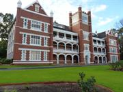
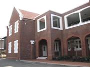
The following statement is drawn from the Register Entry for Place 2379 Wesley College, South Perth prepared in 2009. Wesley College, South Perth, a school complex comprising two storey brick and tile J. F. Ward Wing (1923), Kefford Wing (1925, 1936, 1957-58, 1962-64), J. S. Maloney House (1937) Clive Hamer Building (1940), and H. R. Trenaman Library and Staff common building (1937, 1970); double volume concrete and metal Old Boys’ Memorial Chapel (1961); Old Wesley Collegians’ Association Memorial Lych Gate (1953) and Rose Garden (1995); J. F. Ward Oval (1924); and, Jenkins Quadrangle (1978), set in landscaped gardens of grass, shrubs and established trees, has cultural heritage significance for the following reasons: • the place illustrates aspects of the development of education in Western Australia and is valued by the community of South Perth, the Methodist community and the wider community for its contribution to the education of generations of boys; • Wesley College Old Boys’ Memorial Chapel is a fine representative example of Post War Ecclesiastical style, featuring innovative design and building techniques through the use of reinforced concrete ring beams and precast concrete walls and slabs, built to an award-winning 1960 design by Ross Chisholm; • the place is a cohesive complex of educational buildings, developed from the 1920s to the present (2007) in a manner which, on the whole is architecturally sympathetic to earlier elements; • the place contributes to the community’s sense of place as it has been in the same locality and performing similar educational functions since 1923, during which time the suburb of South Perth has developed around the school and the place has become an intrinsic part of the streetscape and community; and, • the individual elements of the place collectively form an attractive cultural landscape of significant buildings and structures set within an accessible, inviting and pleasing landscape.
Wesley College occupies a 19 hectare site on the ridge of the foreshore escarpment with. View towards the river and the city. The site generally bounded by Mill Point Road, Coode Street, Angelo Street, Tate Street and Leane Street, South Perth. The site comprises three precincts, the Heritage Precinct on the western side of the site, the Senior School Precinct on the eastern side and the Swan Street Precinct, comprising the central section of the school complex. The buildings within the Heritage Precinct are: JF Ward Wing, (1923) – two storey fair face brick with rendered banding displaying elements of the Federation Arts and Crafts style. Originally designed as a single storey three winged building, the upper level was added in 1927 and two single storey additions were constructed between the wings. The original main entrance is on the north façade which has a two storey verandah supported by face brick columns with roughcast panels in between, a clapboard clad two storey bay window in the centre and a gable end punctuated by three double hung sash windows on each level of the east end of the façade. An escape ladder made from a series of steel rungs from WWII remains extant on the brick verandah column. The west elevation with its three prominent gable ends to the wings is set back from Coode Street in a garden setting overlooking the Rose Memorial Garden. Each façade to wings is composed of alternating red face brick columns and rough cast rendered panels above which each of the double hung sash windows are placed. The intersection between the levels is concealed and articulated with a rendered band and stringcourse. The gables are finished in roughcast render with brick panel at the apex. The central wing has terracotta shingled awnings to both levels of windows. Two double height skillion additions have been added between the wings, projecting out into the garden. The upper section is clad with louvers whilst the lower level is open to three sides. Each provides sheltered access into the building. Kefford Wing (1925) – a two storey brick and tile building comprising of two “L” shaped windows with a centrally placed two-storey addition to the north and south elevations. The wing was originally constructed as a single storey single wing building. A second wing mirroring the design of the first was later added followed by additional storeys. The face brick walls are supported by a series of brick buttresses with rendered capping. The original south façade has been partially obscured by the construction of a double height enclosed walkway and reception area. The original features of the façade remain extant and now form part of the internal space. The original timber framed sashes with rendered surrounds are now a feature of this space. Much of the original north elevation has become obscured by a continuous concrete and glass enclosed corridor which connects all the buildings around the Jenkins Quadrangle. JS Maloney House (1937) – two storey brick and tile former Headmaster’s residence and marks the boundary of the original school site. The former house has a symmetrical façade to the north elevation with a central porch entry. The porch has a brick paved floor, openings on the east and west elevations with brick steps and a large centrally placed opening featuring a pair of columns in the Tuscan order and steel balustrading between. All openings feature modern details expressed through lintels of vertically placed bricks and supported by flat steel lintels. Above the porch is an enclosed room with large glazed openings. A corbelled feature on the eastern end of the front façade adds a whimsical touch to the formal façade. On the west elevation the window of the front room has shitter stays which are still extant but no shutters. There is a brick paved verandah approximately mid length of the house, between the front room and the rear rooms. French doors open out onto the verandah. The south elevation overlooks the Rose Memorial Garden has an informal arrangement of windows and roof forms featuring a pair of small dormers and deep eaves against hipped roofs over the main area of the house. The south west corner of the house has been extended and re-roofed with its own hip. A skillion verandah canopy supported on square posts wraps around the south and east elevation. the ground level openings to these two elevations have been altered to incorporate full height windows and sliding doors which has impacted on the aesthetics of the building. Old Wesley Collegians Association Memorial Lych Gate (1953) – a rectilinear structure constructed of limestone blocks and timber stop chamfered posts supporting a terracotta shingled gable roof. It is orientated on a north-south axis. The Wesley College coat of arms is featured on the north and south elevations. Internally there are two integral timber slatted benches and two brass plaques engraves with names of Old Boys who lost their lives during various war. Each name is also represented by a cardinal rose bush in the adjacent Memorial Roe Garden. Rose Garden – cruciform garden containing 56 roses forming an emotive and attractive feature of the west boundary of the school site. Wesley College Old Boys’ Memorial Chapel (1961) the Memorial Chapel is designed in the Post War Ecclesiastical style featuring reinformed concrete ring beams, precast concrete walls and slabs. It is a cylindrical building elevated on a square terrazzo paved podium with a steel portico on the southern side. The roof comprises a series of 12 steel framed sheet metal clad apexes and valleys, surmounted in the entre by a tall steel spire. Each steel valley rafter functions as a gutter draining into 12 strategically located circular pipe columns. Precast concrete panels with exposed aggregate finish are alternated with panels of cement render finish to create a play of dark and light tones on the façade. Alternate panels are set back from the edge of the ring beam to allow for an insert of steel framed louvered glass windows. The congregation enters the Chapel on the south side by means of a small flight of steps onto the elevated terrazzo paved podium through a pair of glazed double doors with vertical glazing bars and into the narthex. There is an alternative eastern side entrance with similarly detailed double doors. HR Trenaman Library (1937) – this building was designed as a single storey brick and tile dining and assembly hall in 1937 with the second storey being added in 1970. The building presents with Inter-War Georgian Revival Characteristics. The ground floor is constructed of red/brown toned brickwork laid in stretcher bond with large openings with three leaded light sash widows to each adding light and formality to the structure. The windows are surrounded by rendered and scribed surrounds installed to replicate quoining. The main entrance is on the wet elevation overlooking the Jenkins Quadrangle, with a single step access. The entrance has ornate plaster moulding and timber double doors. The upper level is obscured from clear view due to the enclosed concrete and glass walkway but it is of face brick construction with large square steel framed openings. Clive Hamer Building (1940) is located in the Senior School Precinct but contributes to the brick built structures of the early buildings and displays characteristics of the Inter-War Georgian Revival and Inter-War Gothic Revival styles. The interior has been adapted and was undergoing further works in January 2018. The south elevation overlooking the Ward Oval is composed of the original four centred pointed arch arcade on the ground floor. There are five large openings with rendered surrounds on the recessed section of the upper floor and both gable ends incorporate two sets of windows, each containing three aluminium framed sashes in a rendered surround. The north elevation almost replicates the south elevation. the recessed section contains the arched openings and the windows in the same manner as the south façade. The eastern gable has three levels of windows including one in the apex of the gable. The western gable has a four-centred arched doorway opening and a single sash window above.
The first Methodist settlers had arrived in the Swan River Colony in 1830. Wesleyan Methodism is associated with the beginnings of education in Western Australia. The first Wesleyan primary school in Perth opened c1835 and provided education services for approximately one quarter of all children enrolled in the colony, not just Methodist children. The Methodist population of Western Australia had increased with immigration from the eastern states following the gold rushes of the 1890s. By the beginning of World War One, the need for a new Wesleyan school was recognised, in particular to meet the needs of farmers’ children requiring city education following several years of rural drought. A Boys’ College Committee, formed in 1916, chose a 9 acre (3.6 ha) site on a ridge overlooking the river in South Perth, purchased in 1919 for £1450. The earliest buildings at Wesley College were designed by architect James Hine, a Methodist parishioner and prominent architect. Hine prepared plans for a single storey E-shaped building, consisting of a headmaster’s residence, dormitory accommodation for up to 25 boarders, and classroom space for around 100 students which was to double as a place for public worship for South Perth Methodists. The foundation stone for the original building was laid on 11 November 1922, by Premier Sir James Mitchell, who declared his opinion that, ‘the boy with the trained, flexible mind made a good farmer’. The building contractor employed to realise Hine’s design was M. Ellyard. Classes commenced on 13 February 1923 and at that time the South Perth area was populated by under three thousand residents. The streets were largely unsealed, much of the surrounding bushland was undeveloped, and public health amenities such as sewerage were yet to arrive. During the 1920s the local population boomed, and the construction of Wesley College represented a major building project in the burgeoning suburb of South Perth. The first headmaster of Wesley College, John Frederick Ward, served from 1923 to 1929. The first class consisted of day scholars from South Perth and surrounding suburbs, and boarders from towns in the Wheatbelt and Great Southern districts. Almost immediately plans were formulated to improve the grounds and add new buildings. A second storey was added in 1927, and, with several new timber single storey buildings, met the need for additional dormitory and classroom space. The work was undertaken by builder A. L. Toms. A plan of the site in 1936 shows that Wesley College, South Perth consisted of two brick buildings; the original building (Ward) and a single-storey classroom on the location of the western part of Kefford. On the remainder of the site were timber and asbestos buildings. The second headmaster, James Leonard Rossiter, served from 1930 to 1952. In 1936, Rossiter moved to rental accommodation off-campus, freeing up rooms for school use. However, the school continued to expand and architects Hobbs, Forbes & Partners were commissioned to produce a master plan for the school. The priorities were to provide a headmaster’s residence and a new block containing classrooms, dining hall, and kitchen, with the buildings to face south with an imposing façade overlooking the oval and Angelo Street entrance. The first stage of the plan involved a single storey building containing classrooms, and a dining hall, defining the south and east sides of a central quadrangle, with provision for addition of second storey extensions. The new dining hall and classrooms were opened on 18 September 1937, by Professor Walter Murdoch. A notable feature of the new dining hall was the stained glass window at the southern end, designed by Wesley Old Boy Arnold Camerer. Also during 1937, the new headmaster’s residence designed by Hobbs and Forbes was completed. The gymnasium (later named the Hamer building) was built during 1940. In the lower level an open undercroft provided a space for boxing contests. This building was designed by architects Eales Cohen and Fitzhardinge. During 1950, the water tower (a well-known local landmark) was removed to make way for extensions to the gymnasium which comprised new changing rooms at the lower end and a new classroom block at the upper end. In 1950, the oval in front of the main building, which had been rolled and planted by staff and students in 1924, was named J. F. Ward Oval after the first headmaster. The Rossiter Oval was named at the same time after the second headmaster. The memorial lych-gate and rose garden, commemorating the 55 former students killed during World War II, was opened in July 1953. The third headmaster, N. R. (Roy) Collins, served from 1953 to 1964 and oversaw future expansion of the college through the acquisition of properties along adjacent streets and the completion of several building projects. The new buildings included a new physics and chemistry labs and undercroft change rooms (1955-56); three new classrooms were added above the old third-year classrooms during 1957-58 (now part of the Kefford wing); a second section of the science building, devoted to biology and manual arts (1958-59) and the Junior boarding house, at the corner of Swan Street and Coode Street, was opened in 1959. The opening of the Narrows Bridge (1959) and Kwinana Freeway encouraged the development of South Perth, Como, and the surrounding suburbs. New southern suburbs such as Rossmoyne and Booragoon provided a wider catchment area for Wesley College. Students increasingly came from non-denominational families. Plans for a chapel finally came to fruition with the construction of the Memorial Chapel during 1960. Old Boy and architect, Ross Chisholm won a competition for the design with a building noted for its innovative and contemporary use of concrete ring beams and precast slabs. The chapel was built by L. Lilleyman Pty. Ltd. In 1962, architects Forbes and Fitzhardinge designed part of the second storey extensions to the existing classroom block which subsequently became the Kefford Wing. A new Olympic-size swimming pool was opened on 27 April 1963. The pool became available for use by the general public. Over the summer of 1963-64, three classrooms built during 1926 were demolished, to make way for a new building comprising six classrooms on two levels, at the western end of the main classroom block (named the Kefford Wing in 1998). The fourth headmaster, Clive Hamer, served from 1965 to 1983. In 1968, plans were prepared by Forbes and Fitzhardinge for the final second storey addition of the Kefford building. At the same time the covered walkway with concrete pillars was added to the Kefford building. The Trenaman Library was built in 1970, over the old dining hall. The foundation stone for the Joseph Green Centre was laid on the 13th February 1973. The Centre, comprising an assembly hall, performing arts space, lecture theatre, and Old Boys’ room, opened in 1974 to commemorate the fiftieth anniversary jubilee of Wesley College. Wesley College became partly co-educational from the late 1970s. In this period the Methodist, Congregational, and Presbyterian Churches amalgamated into the Uniting Church of Australia. A new preparatory school facing the south side of Swan Street was designed by Tony Brand, of Forbes & Fitzhardinge, and constructed by Cooper & Oxley. It was opened on 25 March 1978 by Premier Sir Charles Court. Further additions were undertaken to the original building in 1978 the most significant being the addition of the upper level walkway. This design was prepared by architects Forbes and Fitzhardinge. The fifth headmaster, Roderick Edward Kefford, served from 1984 to 1996. Over summer 1984 to 1985, squash courts in Tranby boarding house were converted into dormitories. Also in 1985 construction began on the Robert Blanckensee Physical Education Centre which was completed in 1987. The opening of the Blanckensee Centre allowed redevelopment of the gymnasium (built 1940) as senior school classrooms. The refurbished building, named the Hamer Building after the former headmaster, opened on 2 July 1989. Four houses, one on Coode Street, and three on Mill Point Road, were demolished in late 1992 to make way for a preparatory school resource centre, which was opened on 10 April 1994 by Premier Richard Court. By 1995, over a third of boarders were full fee paying overseas students, often from families practising Islam. Wesley College has shifted its client base over its history, from the original students from mainly lower middle-class families practising Methodism, through to the more affluent families of mixed religious affiliations who moved into the southern suburbs from the 1950s onward, to the multicultural student body of recent decades. The place reflects the broad demographic shifts in the surrounding area. A new design and technology building was completed in 2004 and in the following year the Memorial Lych Gate was relocated. The site is constantly being assessed for the school’s future needs and developed in response to these changing needs. The school administrators have sympathy for the heritage buildings on the site and the new buildings on the site have been designed sympathetically to the existing buildings.
High / Moderate
Good
| Name | Type | Year From | Year To |
|---|---|---|---|
| Eals, Cohen & Fitzharding (Gym) | Architect | 1940 | 1940 |
| Hoobs, Forbes & Partners | Architect | 1947 | 1947 |
| Ross Chrissholm (chapel) | Architect | 1960 | 1960 |
| J. Flower | Architect | 1996 | 1997 |
| Forbes & Fitzharding | Architect | 1962 | 1978 |
| J. Hine | Architect | 1923 | 1928 |
| Ref ID No | Ref Name | Ref Source | Ref Date |
|---|---|---|---|
| Florey, Cecil. "Peninsular City: A Social History of the City of South Perth" | City of South Perth WA | 1995 | |
| "Cosmopolitan Past for Old Bell Tower" in "Southern Gazette" page page 32 | 16/5/1995 | ||
| Historical Notes | Provided by Barbara van Bronsijk, Wesley College Archivist | 1998 |
| Reserve | Lot/Location | Plan/Diagram | Vol/Folio |
|---|---|---|---|
| 504 | 27361 | 1686-383 |
| Owner | Category |
|---|---|
| Welsey College | Other Private |
This information is provided voluntarily as a public service. The information provided is made available in good faith and is derived from sources believed to be reliable and accurate. However, the information is provided solely on the basis that readers will be responsible for making their own assessment of the matters discussed herein and are advised to verify all relevant representations, statements and information.
25 Forrest St South Perth
South Perth
Metropolitan
| Type | Status | Date | Documents |
|---|---|---|---|
| (no listings) |
| Type | Status | Date | Documents |
|---|---|---|---|
| (no listings) |
| Type | Status | Date | Grading/Management | |
|---|---|---|---|---|
| Category | ||||
| Municipal Inventory | Adopted | 14 Nov 2000 | Category A+ | |
02383 St Columba's Church Group & St Joseph's Convent, South Perth
Individual Building or Group
| Epoch | General | Specific |
|---|---|---|
| Original Use | RELIGIOUS | Church, Cathedral or Chapel |
| Present Use | RELIGIOUS | Church, Cathedral or Chapel |
| Style |
|---|
| Inter-War Romanesque |
| Type | General | Specific |
|---|---|---|
| Wall | BRICK | Rendered Brick |
| Roof | TILE | Terracotta Tile |
| General | Specific |
|---|---|
| SOCIAL & CIVIC ACTIVITIES | Religion |
This information is provided voluntarily as a public service. The information provided is made available in good faith and is derived from sources believed to be reliable and accurate. However, the information is provided solely on the basis that readers will be responsible for making their own assessment of the matters discussed herein and are advised to verify all relevant representations, statements and information.
Constructed from 1937, Constructed from 1936
Saint Columba’s Church is an uncommon, but fine, generally intact example of the Inter-War Romanesques style in Perth. The building is located in a prominent location along the south Perth foreshore of the Swan River and forms a significant component of the amphitheatre of buildings around Perth Water and has landmark qualities. The coloured leadlight glazing throughout, together with the carving and colouring of the roof trusses in the nave is of aesthetic significance. Saint Columba’s Church marks the focus of almost a century of the presence of the Roman Catholic Church in South Perth and makes a meaningful contribution to the sense of place of both the pastoral and local community.
The Saint Columba’s Church site is on elevated land along the southern shore of the Swan River, overlooking the City of Perth to the north. The buildings on the site, while highly visible from Perth do not set out to take advantage of the outlook available. The orientation of the axis of the church is north and south, a signature of the architecture of E Le B Henderson, probably intended to reduce insolation during the main service in the late morning. The narthex of the church is at the north (river) end leading through doors on the east and west into a simple, elongated nave with a five sided apse at the southern end containing the altar. A bell tower surmounted by a cupola is at the north western corner of the building and chapels and the sacristy open as transepts from each side of the southern end of the nave. The structure of the Saint Columba’s Church building is modulated by brick piers separated by coupled pairs of elongated arch headed windows while the north wall is punctured by a rose window with trefoil pattern tracery. Construction materials: The building is probably a brick structure, rendered both internally (to simulate coursed stretcher stonework) and externally with textured material. The roof is saddle-backed and clad externally with terra cotta Cordova tiles with their ends at the eaves, unfortunately concealed by the eaves gutter. The recent addition of rectangular metal sun screens over all the external voids, except the rose window and the doors, conceals the elevational impact and design style of the building. There are extensive unrelieved red brick paved driveways and paths around the perimeter of the building/ Internally, the altar is to some extent overpowered by the richness of the decoration of the Douglas Fir roof trusses in the nave. These are sprung from timber corbels at the plates and the tie member has bosses at the intersection of the post web members. An unusual blind member added to the king post recants the cross motif. All of the truss members are stop chamfered and heavily decorated and coloured with Spanish Mission motifs. Above the trusses, the ceiling is clear finished jarrah boarding which carries through into the apse.The arch of the apse is reinforced with a simple twisted black wrought iron tie structure, the ceiling is clear finished jarrah tongued and grooved boards. The steps of the apse rise from the floor of the nave in white Carrara marble with matching pulpit in white marble staves with fan vault motif over, the reredos in the Serliana motif having brown marble inserts and a simple altar also with brown inserts and a marble font. The two pairs of round arch headed windows in the south wall segments of the apse are coupled by hood-moulds over. Details of the coloured leadlighting glazing in Saint Columba’s Church is contained in the National Trust Assessment. The pews, six confessionals, stairs, balustrading and choir balcony are in clear finished jarrah. The Presbytery located a short distance to the west of the church is a simple, single storey, brick and tiled building in a domestic scale of little architectural importance. The two buildings are in good condition. The integrity of the exterior of the building has, to a minor degree been reduced by the superimposition of modern brise-soleil panels over the majority of the windows thereby losing their characteristic Romanesque shape. Further, the changes to the materials comprising the exterior driveways and paths imbue the building with an ‘over restored appearance’. These changes are nevertheless considered appropriate adaptations for modern usage.
Saint Columba’s Church was built in 1936-37 on land which the Catholic Church had owned in South Perth since the late 1880s. Until then a small band of priests and nuns served the very large Victoria Park parish which had been created in 1896 and then covered the area from South Perth to the present day Belmont. The Sisters of Mercy extended their mission into the South Perth area some time early in the century, with the work of Catholic education actually taking place in private homes. Around 1905 South Perth was given parish status and a convent was established in South Perth. In 1914 the architect RJ Dennehy sold his residence to the Order for £3,000. (Refer Pl No. SPCnt 1 Dennehy House - Saint Joseph’s Convent). In 1917 Father Raphael Pace became the first parish priest of the official South Perth parish. By 1932 Father John McMahon was in charge, and after a visit to California, he was inspired by the work of the Spanish Franciscan Friar-missionary, Fr Junipero Serra, who created a network of missions along the Californian coast. Back in Western Australia, architect E Le B Henderson modified some aspects of the ‘mission style’ in drawing up plans for a new church in South Perth, to be known as Saint Columba’s Church. The design was a complete departure from local ecclesiastical architecture. The foundation stone was laid in December 1936, and the opening took place just 16 weeks later. About fifty years later a parish centre was built on the site, as part of Saint Columba’s 50th anniversary celebrations.
High
Very Good
| Name | Type | Year From | Year To |
|---|---|---|---|
| E. Le B. Henderson | Architect | - | - |
| Owner | Category |
|---|---|
| Roman Catholic Archbishop of Perth | Church Property |
This information is provided voluntarily as a public service. The information provided is made available in good faith and is derived from sources believed to be reliable and accurate. However, the information is provided solely on the basis that readers will be responsible for making their own assessment of the matters discussed herein and are advised to verify all relevant representations, statements and information.
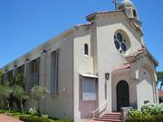
25 Forrest St South Perth
Intersection Forrest/York/Hopetoun/Alexander Streets - includes the school, presbytery, church and convent
South Perth
Metropolitan
Constructed from 1908 to 1939
| Type | Status | Date | Documents |
|---|---|---|---|
| Heritage List | Adopted | 28 Feb 1996 | |
| State Register | Registered | 21 Apr 2006 | HCWebsite.Listing+ListingDocument, HCWebsite.Listing+ListingDocument |
| Type | Status | Date | Documents |
|---|---|---|---|
| (no listings) |
| Type | Status | Date | Grading/Management | |
|---|---|---|---|---|
| Category | ||||
| Art Deco Significant Bldg Survey | Completed | |||
| Catholic Church Inventory | Completed | 01 Jul 1998 | ||
| Municipal Inventory | Adopted | 28 Feb 1996 | ||
good
| Name | Type | Year From | Year To |
|---|---|---|---|
| E. Le. B Henderson | Architect | - | - |
| Richard Joseph Dennehy | Architect | 1906 | - |
| Library Id | Title | Medium | Year Of Publication |
|---|---|---|---|
| 10180 | St Columba's Church South Perth, Western Australia | Heritage Study {Cons'n Plan} | 2013 |
Individual Building or Group
| Epoch | General | Specific |
|---|---|---|
| Original Use | RELIGIOUS | Monastery or Convent |
| Present Use | RELIGIOUS | Church, Cathedral or Chapel |
| Original Use | RELIGIOUS | Church, Cathedral or Chapel |
| Original Use | EDUCATIONAL | Primary School |
| Original Use | RELIGIOUS | Housing or Quarters |
| Present Use | RELIGIOUS | Monastery or Convent |
| Present Use | EDUCATIONAL | Primary School |
| Present Use | RELIGIOUS | Housing or Quarters |
| Style |
|---|
| Federation Queen Anne |
| Inter-War Romanesque |
| Type | General | Specific |
|---|---|---|
| Roof | TILE | Terracotta Tile |
| Wall | BRICK | Common Brick |
| General | Specific |
|---|---|
| SOCIAL & CIVIC ACTIVITIES | Religion |
| SOCIAL & CIVIC ACTIVITIES | Education & science |
This information is provided voluntarily as a public service. The information provided is made available in good faith and is derived from sources believed to be reliable and accurate. However, the information is provided solely on the basis that readers will be responsible for making their own assessment of the matters discussed herein and are advised to verify all relevant representations, statements and information.
Constructed from 1936, Constructed from 1937
02383 St Columba's Church Group & St Joseph's Convent, South Perth
The following statement is drawn from the Heritage Council of Western Australia Register entry for the inclusion of St Columba's Church Group & St Joseph's Convent, South Perth in the State Register of Heritage Places. St Columba’s Church Group & St Joseph’s Convent, South Perth, comprising St Columba’s Church (1937), Presbytery (1938), Church Centre (1986), St Columba’s Catholic Primary School (1908-2002), Dennehy House (1908), Mary MacKillop Centre (1927), Chapel (1939) and Chapel Unit (1939, 1974), the Cloisters, Convent (1957, 1974), Irene Villa (1959/60, 1982), MacKillop Court (1971), and Irene McCormack memorial rose garden (1992) has cultural heritage significance for the following reasons: • the place is an intact collection of buildings forming an historic Catholic group and, distinguished by the prominence of the site, is a regional landmark; • the place demonstrates the expansion of the Catholic Church in Western Australia during the time of Bishop Mathew Gibney (1887-1910), Archbishop Patrick Clune (1911-1935) and Archbishop Redmond Prendiville (1935-1968) and the role played by Irish Religious Orders in the establishment of Roman Catholicism in Australia in the nineteenth and twentieth century; • St Columba’s Church is a fine example of the Inter-War Romanesque style with Spanish Mission influences, exhibiting smooth rendered facades, elegant proportions, and fine interior detailing. Its design represents early attempts to build ecclesiastical structures that were appropriate to the climatic and cultural conditions of southern Western Australia; • St Columba’s Church features excellently crafted stained glass windows, with intense and deep colours designed specifically to exploit Western Australian sunlight, which contribute to the splendour of the interior space; • the St Joseph’s Convent buildings are an aesthetically pleasing complex dominated by Dennehy House, a well-resolved and fine example of the Federation Queen Anne style, Mary MacKillop Centre, an attractive two storey building featuring a distinctive two-storey timber verandah with paired timber columns, and the Chapel, which features an impressive interior and marble sanctuary; • the place is significant for its association with prominent Catholic Religious in Western Australia, including the Rev. Dr John Thomas McMahon, Archbishop Patrick Clune, Archbishop Redmond Prendiville, the Sisters of Mercy and the Sisters of St Joseph; • the place is associated with Richard John Dennehy, well-known Western Australian architect and prominent Catholic layman, who designed the first church-school on the site in 1908, and its extension in 1919, as well as his own 1908 York Street home, that was purchased by the Sisters of St Joseph for a convent in 1914; and, • the place is highly valued by the Catholic community as an important focus of their religious life. It also contributes to the sense of place of the wider community, due to its prominent location and distinctive aesthetic characteristics. Irene Villa (1959/60, 1982), MacKillop Court (1971), the Convent (1957, 1974), swimming pool, Link/Garden Room, and garage are of little significance.
St Columba’s Church Group & St Joseph’s Convent, South Perth comprises: St Columba’s Church Group: St Columba’s Church (1937), Presbytery (1938), Church Centre (1986), St Columba’s Catholic Primary School (1908, 1919, 1949,1985, 1990, 2002), and; St Joseph’s Convent: Dennehy House (1908), Mary MacKillop Centre (1927), Chapel (1939), Convent (1957, 1974), Irene Villa (1959/60, 1982), and MacKillop Court (1971). St Columba’s Church, Church Centre and the Primary School are located on the west side of Forrest Street, set in landscaped grounds on the rise of the hill bounded by Hopetoun Street, Alexandra Street, and York Street. St Joseph’s Convent comprises a complex of one and two-storey brick and tile buildings, including Dennehy House (1908), the Mary MacKillop Centre (1927), Chapel (1939), the Convent (1957, 1974), Irene Villa (1959-60, 1982), and MacKillop Court (1971), set amongst expansive scenic gardens the site is located on the northern side of York Street and is bound by Alexandra Street to the east and King Edward Street to the west, residential buildings are located to the north. The Saint Columba’s Church is a highly distinctive building built on elevated position in landscaped gardens. The church is of rendered brick construction with Marseille tile roof and is a good example of an inter-war building displaying elements of the Romanesque and Spanish Mission architectural styles. It comprises a free standing smooth rendered brick building with a medium pitched tiled gable roof. The church has an orthogonal planform with a projecting front entry porch on the north elevation with doorways to both the east and west elevation of the porch. The Presbytery located a short distance to the west of the church is a single storey rendered brick and terracotta building constructed in the inter-war Spanish Mission style with distinctive arched openings to most elevations. St Columba’s Catholic Primary School is located to the south of St Columba’s Church and comprises a complex of single-storey face-brick and iron buildings, and rendered brick and tile buildings set within modest-sized grounds. The earliest school building, which is the earliest building of St Columba’s Church Group, is the 1908 Parish Hall, located on York Street and comprises a single storey face-brick building with a steeply-pitched Colorbond roof and entry on the south elevation. St Joseph’s Convent comprises a complex of one and two-storey brick and tile buildings, including Dennehy House (1908), the Mary MacKillop Centre (1927), Chapel (1939), the Convent (1957, 1974), Irene Villa (1959-60, 1982), and MacKillop Court (1971), set amongst expansive scenic gardens. Dennehy House (1908) comprises a two-storey brick and tile building in the Federation Queen Anne style, featuring a picturesque asymmetrical form, warm face-brickwork contrasted against ornate timber detailing and Donnybrook stone, and accents on the roofline including a belvedere and tall masonry chimneys. Entry to Dennehy House is from York Street, via the large timber verandah on the south elevation. This verandah has paired timber columns supporting the first floor balcony, and features a decorative tiled floor and a timber lattice valance (not an original detail). The first floor balcony also has paired timber columns, as well as ornate timber floor joists and filigreed metal balustrades. Mary MacKillop Centre (1927) is located to the west of Dennehy House and connected to both the ground and first floor verandahs is the Mary MacKillop Centre, constructed in 1927 as the Convent boarding school. The Mary MacKillop Centre comprises a two-storey red face-brick and tile building with a spreading hipped roof and a distinctive two storey timber-framed verandah across its south (York Street) elevation. Another verandah extends along the rear (north) and side (east) elevations, although parts have been infilled. The verandahs typically have paired timber columns (except in front of the entry off York Street) supporting the first floor balcony and feature a timber lattice valance and timber balustrade, designed to match the materials and aesthetic of Dennehy House. The Chapel (1939) is located to the east of Dennehy House and comprises a single storey ecclesiastical building constructed of red face-brick with a steeply-pitched tiled roof, a projecting porch on the south elevation (added in 1970), a chapel unit to the northeast (altered and extended in 1972-74), buttresses along the east and west elevations and vertically-proportioned arched windows. Primary entry to the Chapel is from the west, directly into the nave via an enclosed brick cloister that connects directly to Dennehy House, or from the south, via the porch. The Convent (1957, 1974) is the main accommodation wing of the complex and comprises a two-storey face-brick and tile building located immediately north of the Mary MacKillop Centre. The ground floor comprises the main kitchen, dining room and laundry, while the first floor, also known as ‘Our Lady’s’, comprises six residential units. The Our Lady’s Wing with nine units is located at the northern end of the building. Irene Villa (1959-60, 1982), formerly known as St Joseph’s Nursing Home, comprises a single-storey brick and tile residential building, basically rectangular in plan, located north of Dennehy House. MacKillop Court (1971) comprises a one and two-storey brick and tile residential building located north of Irene Villa, and connected to St Joseph’s Convent by way of a multi-storey link known as the Garden Room (1995). MacKillop Court has eight units for retired/senior Sisters, and a flat and guest room at the eastern end.
The following information is largely drawn from the Heritage Council of Western Australia Assessment document prepared in April 2006 for the inclusion of St Columba's Church Group & St Joseph's Convent, South Perth in the State Register of Heritage Places. The growth of South Perth was slow until the 1880s, by which time communication with Perth was improved with the introduction of ferry services and construction of bridges across the Swan and Canning Rivers. The discovery of gold in Western Australia from 1885 led to an increase in population, with land facing Perth Water progressively sub-divided between 1886 and 1904. The gold discoveries also led to an influx of lay Catholics from the eastern states of Australia. This increase in the Catholic population prompted the Bishop to seek more members of Religious orders to serve them. The Catholic Church secured land in South Perth in the 1880s. Until then, a small band of priests and nuns served the very large Victoria Park parish and covered the area from South Perth to the present day Belmont. The Sisters of Mercy extended their mission into the South Perth area some time early in the century, with the work of Catholic education actually taking place in private homes. Around 1905, South Perth was given parish status and in 1908 a church and school was established in South Perth on portion of the Catholic Church landholding bound by King Edward, York, Forrest and Hopetoun Streets. Tenders were called in 1907 for the erection of a (Catholic) school, church and hall on the corner of York and Forrest Streets, South Perth. By 28 March 1908, a new school-church was completed on the York Street site, run by the Victoria Park-based Sisters of Mercy, with an initial enrolment of about 35 pupils. The establishment was then known as the St Columba Roman Catholic School. The modest red brick and tile building had been designed by architect, Richard Joseph Dennehy. Dennehy born in Ireland in 1854, migrated with his family to Australia in 1855. He trained as an architect in Melbourne and worked there and in Sydney before relocating to the Western Australian goldfields in the mid 1890s. The Dennehy family, consisting of Richard, his wife Marion nee O'Halloran, and six children, settled in Perth in 1898. Dennehy established a successful practice in Perth, and as a practicing Catholic he took up many projects for the Catholic community, including the Home of the Good Shepherd in West Leederville, (1898), and the Church of the Sacred Heart in Leederville (1905). Dennehy had a productive year in 1908 designing several prominent projects in Perth; Moana Chambers in Hay Street and the Connor Quinlan Building on Barrack Street. Given his ongoing success it is not surprising Dennehy decided to build a large home for his family on the elevated site adjacent to the school and church he designed for the Catholic Church. Sadly Marion Dennehy (c1855-1903) had died in 1903 and Dennehy lived at this new home, with his youngest daughters from 1909. The builder of the residence has not been determined in this research. Dennehy named his home 'Joyous Gard', which in British mythology was the name of the home of Lancelot, one of the knights of King Arthur. In 1910, it was published that Dennehy ‘makes a hobby of gardening and finds health and recreation in the cultivation of choice blooms in his garden plots at South Perth where he resides with his three daughters’. In 1914, Dennehy sold his residence for £3,000 to the Sisters of Saint Joseph who took over the St Columba Roman Catholic School from 1915. In a letter from Dennehy to the Sisters in June 1914 he provided a lengthy description of the grounds, buildings, fittings and fixtures. In summary, he believed his asking price was a bargain at the price agreed, as ‘the house alone would cost more that that amount to built, to say nothing of the grounds and improvements’. The home was used as a convent for the sisters who had previously lived in Victoria Park, and a secondary boarding school, advertised by the Josephite Sisters as ‘Mount St Joseph’s’ (or as Mount St Joseph Roman Catholic School), ‘in one of the most attractive and healthy suburbs of Perth’ with ‘a delightful view of the Swan River’. At the start of the 1915 school year, there were three boarders enrolled (one from Boulder and two from New Norcia) and by April, there were twelve borders at Mount St Joseph’s. By the end of 1915, there were 88 children, including the boarders, enrolled at Mount St Joseph’s. The course of study at Mount St Joseph’s included ‘all the branches of a thorough English Education’, as well as modern languages, mathematics, elocution, physical culture, drawing, painting, music and needlework. Special facilities were also available for students who wanted to pursue courses in stenography, typewriting and book-keeping. Pupils were also prepared for ‘University, Commercial and Music Examinations’. In addition, for ‘delightful situation, beautiful scenery and healthy climate’, Mount St Joseph’s ‘[stood] unrivalled’. In 1917, Father Raphael Pace became the first parish priest of the official South Perth parish. In 1919, Fr Pace engaged Richard Dennehy to organize the building of two new class room wings, so as to leave the existing school-church hall as a Kindergarten during the week and a Mass centre on Sundays. Father Pace remained at South Perth until 1926, when he moved on to serve other parishes in the State. He was succeeded at South Perth by Dean D.A. Brennan, an Irish-born priest ordained in 1899, who remained at South Perth until 1932, when he was transferred to Victoria Park and later West Perth. Dean Brennan remained living in the South Perth Presbytery for some months after his transfer to Victoria Park, obliging the incoming parish priest, Reverend Doctor John Thomas McMahon, to reside at the Hurlingham Hotel, nearby on Canning Highway. John T. McMahon was born in Ennis, Ireland, in 1893 and was ordained a priest at All Hallows College in Dublin in 1919. Fr McMahon had arrived in Perth from Europe on 17 February 1921, the following year, Archbishop Clune appointed Fr McMahon as his Diocesan Inspector of Catholic Schools. In 1925, McMahon established the Newman Society at the University of Western Australia in order to facilitate the ongoing religious development of Catholic Graduates and Undergraduates. In addition to these activities, Fr McMahon was appointed editor of the Catholic weekly newspaper, the Record, from 1928 to 1932. In 1927, a large two storey extension was constructed in similar materials to the original Dennehy house immediately to the west of the Convent of the Sisters of St Joseph, to house boarding students of the Mount St Joseph Convent School. The work on the extension, built at a cost of £6,719, was carried out by Berry Brothers, builders, to a design by Richard Dennehy. Also in 1926, the Sisters of Joseph acquired Lots 72 and 73, King Edward Street, South Perth, blocks adjoining the Convent property. On Sunday 24 April 1932, Archbishop Clune inducted the Fr McMahon as Parish Priest of South Perth. At that time, the Archbishop urged the parishioners to co-operate with their new priest to build a church on their ‘unrivalled site’. This land on Forrest Street faced the (Victoria Avenue) Cathedral across the river and, being 70 feet higher than the land on which the Cathedral was situated, commanded one of the most prominent positions in Perth. The site demanded then, according to Clune, ‘a church worthy of such a view’. On the same day, members of the St Columba’s Church committee met, and were unanimous in their decision to make the construction of a church the objective of all efforts in the Parish. Through vigorous fundraising activity in the district, the Parish was able to collect £12,000 by the end of 1937. The design of the church was influenced by a visit McMahon had taken in the later 1920s, to a priest-friend in Hollywood, where he had been impressed by the ‘Mission Style’ architecture that was very fashionable in the warmer parts of California. It was the type of building favoured by Father Junipero Serra for the 21 missions he had established along the Californian coast in the second half of the eighteenth century. As well as being influenced by the ‘Mission Style’, Los Angeles architect Thomas F. Power, commissioned to draw up the plans for the Hollywood Church, chose a largely Italian-Byzantine style, modelling the building and its decorations after St. Sophia Basilica in Istanbul and St. Mark Cathedral in Venice. Supplied with photographs and blueprints of the Hollywood Church of Christ the King, Dr McMahon returned to Western Australia, eager to have the South Perth church built in a similar style. Some time later, Perth architect E. Le B. Henderson modified the plans to suit the local situation, resulting in a style that Dr McMahon described as ‘an adaptation of the Mission treatment of Byzanto-Romanesque'. In April 1936, Archbishop of Perth, Redmond Prendiville, and two members of the Committee on Sites and Buildings, selected the exact site for St Columba’s Church in South Perth, on the highest point of land in the area. It was noted in 'The Record' that the site was chosen so that ‘no future developments in parochial building [would] ever break the unbroken line of the Church from across the water’. In September 1936, tenders were called for the construction of St Columba’s Church. At the same time, parishioners began a series of ‘busy-bees’ to clear the site in preparation for construction. Later, in September 1936, the contract for construction of St Columba’s Church was let to William Fairweather and Son, whose tender of £6,686 was the lowest of the eight received. The Church was to provide comfortable seating on seasoned jarrah pews for 450 people, while the mezzanine organ gallery was to hold an extra 200 people. In early October 1936, the first bricks were laid for the walls of the South Perth Church, and it was planned that the new building would be opened in April of the following year. The foundation stone for the new Church was laid by Archbishop Prendiville on Sunday 13 December 1936, which was also the 43rd birthday of Dr McMahon. On 11 April 1937, St Columba’s Church was officially opened by the Archbishop. The details of the church design and its finishes and fittings were widely covered in the local press and although there were many fine details the stained glass of the Rose Window above the choir loft was noted for its quality of design and manufacture. This window was made in Dublin, Ireland, by the firm of Harry Clarke Ltd. The Rose Window consisted of three large circles, shaped in a shamrock formation, with an image of St Patrick in the crowning leaf, and St Brigid and St Columba in the supporting leaves. Not long after the opening of St Columba’s Church in early 1937, plans for a new Presbytery on the Forrest Street site were drawn up. In December 1938, the new quarters, designed and built by Horace Costello to be low maintenance, were completed. The Presbytery was built in the ‘Spanish Villa style’ to complement the ‘Spanish Mission church’. In 1938, following the construction of St Columba’s Church and Presbytery, it was considered appropriate that both the primary school and the secondary school operate under the same name, Mount St Joseph’s was subsequently renamed St Columba’s. In 1939, a two story building to house the chapel for the Sisters of St Joseph was built to the east of the original Dennehy house by A.T. Brine and Sons, builders. The plans were developed by architects Hennessy and Hennessy. The major work on the Chapel was completed for a cost of around £6,554. Other building work carried out at this time included additions to the kitchen and laundry, and a new bathroom and lavatory. In 1940, a new brick fence was built along the York Street boundary by A.T Brine at a cost of £374. At the outbreak of the Second World War, Dr McMahon buried the stained glass windows in crates in the grounds of the Church, in order to protect these unique works from possible enemy bombing raids on Perth. When the crates were dug up at the end of the War, it was discovered that some of the bronze wire in the windows was damaged, and that the piece of glass containing the name of St Brigid was broken. This was replaced by a piece of blue glass, noticeably different from the original. When the window was returned to its position St Columba was placed at the top. The secondary school stopped taking boarders in 1947. The school on the convent site ceased in 1949. Although with the growth of the South Perth Parish in the post-War period, it became necessary to build a substantial new school building immediately to the north west of the original school. In January 1948, the foundations for the new school (designed by architects, Henderson and Thompson), comprising three class rooms 26’ x 24’, a rest room for the Sisters, and a cloakroom with a verandah 10’ wide. Construction was by Berry Brothers, at a cost of £4,142. In February 1949, the new brick and tiled building was blessed and opened by Archbishop Prendiville. In 1950, four stained glass windows were installed in the Sanctuary of the Church, to replace the existing windows of the coloured leadlight glass. These new windows were the work of Dublin craftsman and artist, Richard King, who trained in stained glass work in the studio of Harry Clarke. Later, in 1969, skylights were installed above the altar, doing away with the necessity of extra lighting in the daytime. In 1950, new frames and windows were installed in the Chapel of the Sisters of St Joseph by W.F. Broderick. The following year, a verandah at the Convent was enclosed for a ‘sleep-out’ by A. and L. Power, while, in 1957, a new single storey wing, including a kitchen and lunch room, was built at the back of the existing boarding wing. From 1950 to 1955, three new parishes were split off from the original South Perth Parish: Kensington in 1950, Manning in 1953, and Como in 1955. These developments reduced considerably the size of the congregation of St Columba’s Church. In 1959-1960, an ‘infirmary’ (a 13-bed ‘C’ Class hospital - St Joseph’s Nursing Home) was built for the Sisters of St Joseph by J. Bianchini, behind the Chapel and the original Dennehy House. Works were carried out to the Chapel, Laundry and Community Room at this time. In the period following the annual meetings in the Vatican of the Council Fathers from 1962 to 1965, “Vatican II”, for the purpose of aggiornmento (updating, modernizing or renewing), major liturgical and doctrinal changes were introduced throughout the Roman Catholic world. These changes had implications for the physical layout of churches, and affected both St Columba’s Church and the St Joseph’s Convent Chapel, as they did all other Catholic institutions. In the renovation of church interiors which followed from this changed perspective, the primary focus was to be on the altar, on the ambo or lectern, on the chair of the presiding priest, then on the baptismal font and the tabernacle. Around 1964-65, the original dining room of the 1908 Convent building was extended to the west, greatly increasing the available space. On Sunday 27 June 1965, the 11am Mass at St Columba’s Church was broadcast by A.B.C. Television, with the celebrant facing the congregation for the first time. In the same year, a new Hammond organ was installed by Musgroves at a cost of £1,250. Also in 1965, a bell was blessed and installed in the tower of St Columba’s Church. The bell had been cast by the Mathew O’Byrne Bell Foundry of Dublin. In 1967, a row of 35 year old pine trees on Forrest Street was removed by the Church, as they were liable to fall over or break because of their poor health. On 6 March 1968, a lightning storm struck the tower of St Columba’s Church, It made a large hole in the dome of the tower which broke off fittings from the bell, and tore about 200 tiles from the roof. Between 1970 and 1972, the Sisters of St Joseph built an aged person’s home. This building, named MacKillop Court, was situated behind the Nursing Home. In 1973-74, chaplain’s quarters adjoining the Chapel were built by Bianchini to a design by Henderson and Thompson, architects. The same builder and architect were also responsible for the construction of a second storey on the 1957 Our Lady’s Wing. In 1975, a swimming pool was built to the rear of the Convent land. In 1979, Rev Dr J.T. McMahon retired as the Parish Priest of St Columba’s Church, after forty-seven years of service to the Catholic community of South Perth. His successor was Irish-born Father Michael Casey, who had also received his clerical training at All Hallows College in Dublin. In 1977, E. G. Gowers and A. S. Brown restored the Rose Window which was buckled and deteriorated and in 1993, 1999-2001 work was again undertaken on the Rose Window. In 1978-79, extensions and additions to the Sisters of St Joseph Nursing Home were carried out by Bianchini for around $60,760. In 1985, a new wing was added to the school, containing a library and an extra classroom. At this time, the principal of the school passed to a lay head, ending seventy years of involvement in Catholic education in the South Perth Parish by the Order of the Sisters of St Joseph of the Sacred Heart. In 1986, a large new Church Centre was constructed on the St Columba’s Church site. This building was opened and blessed on Sunday 14 December 1986, the 50th Anniversary of the laying of the Foundation Stone for St Columba’s Church. The Church Centre was designed by A.J. O’Hara, Architect, and constructed by builder K.R. Stewart. In 1992, a Memorial was established in the Convent grounds to Irene McCormack, a Josephite Sister killed by anti-government rebels in Peru on 21 May 1991 while serving the local Peruvian community. In 1994-95, renovations were carried out to the original 1908 Convent building including tuckpointing and replacement of worn timber. In 2018, St Columba’s Church Group & St Joseph’s Convent, South Perth continues in its original purpose. St Columba’s Church is the main place of worship for the Catholic community of South Perth, with the Presbytery providing accommodation for parish clergy and the Parish Office used for administration and for meetings. St Columba’s Catholic Primary School provides a primary education. The original 1908 school building is now the parish hall. St Joseph’s Convent providing living and administrative space for the Order.
High / High
Good
| Name | Type | Year From | Year To |
|---|---|---|---|
| Richard John Dennehy | Architect | - | - |
| E Le B Henderson | Architect | - | - |
| Reserve | Lot/Location | Plan/Diagram | Vol/Folio |
|---|---|---|---|
| 1 | 69889 | 2065-2 | |
| 3 | 41944 | 525-124A |
| Owner | Category |
|---|---|
| Roman Catholic Archbishop of Perth | Church Property |
This information is provided voluntarily as a public service. The information provided is made available in good faith and is derived from sources believed to be reliable and accurate. However, the information is provided solely on the basis that readers will be responsible for making their own assessment of the matters discussed herein and are advised to verify all relevant representations, statements and information.
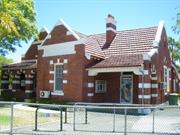
1 Mends St South Perth
Also fronts Labouchere Road
South Perth
Metropolitan
Constructed from 1908
| Type | Status | Date | Documents |
|---|---|---|---|
| Heritage List | Adopted | 14 Nov 2000 | |
| Heritage Agreement | YES | 19 May 2014 | HCWebsite.Listing+ListingDocument |
| State Register | Registered | 28 Nov 2003 | HCWebsite.Listing+ListingDocument, HCWebsite.Listing+ListingDocument |
| Type | Status | Date | Documents |
|---|---|---|---|
| (no listings) |
| Type | Status | Date | Grading/Management | |
|---|---|---|---|---|
| Category | ||||
| (no listings) | ||||
15843 South Perth Historic Village Precinct
| Name | Type | Year From | Year To |
|---|---|---|---|
| Hillson Beasley | Architect | - | - |
| Library Id | Title | Medium | Year Of Publication |
|---|---|---|---|
| 6098 | Conservation plan for South Perth Police Station (1908). | Heritage Study {Cons'n Plan} | 2002 |
Individual Building or Group
| Epoch | General | Specific |
|---|---|---|
| Present Use | VACANT\UNUSED | Vacant\Unused |
| Original Use | GOVERNMENTAL | Police Station or Quarters |
| Style |
|---|
| Federation Free Style |
| Federation Gothic |
| Type | General | Specific |
|---|---|---|
| Wall | BRICK | Common Brick |
| Roof | TILE | Terracotta Tile |
| General | Specific |
|---|---|
| SOCIAL & CIVIC ACTIVITIES | Law & order |
| SOCIAL & CIVIC ACTIVITIES | Community services & utilities |
This information is provided voluntarily as a public service. The information provided is made available in good faith and is derived from sources believed to be reliable and accurate. However, the information is provided solely on the basis that readers will be responsible for making their own assessment of the matters discussed herein and are advised to verify all relevant representations, statements and information.
Constructed from 1908
The following statement is drawn from the Heritage Council of Western Australia Register entry for the inclusion of South Perth Police Station (fmr) in the State Register of Heritage Places in 2003. South Perth Police Station (fmr), a single storey brick building with a Marseilles pattern tile roof, constructed in the Federation Free Style with stylistic elements of Federation Gothic, has cultural heritage significance for the following reasons: • the place is an intact and relatively well maintained example of an early twentieth century public building and is representative example of Federation Free Style of architecture; • the place is an important and familiar landmark in South Perth having a double frontage to two main streets, Labouchere Road and Mends Street. The place has an enhanced prominence by its steeply pitched roof and striking striated style of detailing contrasting red brick with white stucco bands known as ‘blood and bandages’; • the place is contemporary with a group of civic buildings within the immediate vicinity of similar domestic style and scale; which together coherently form a small town centre and constitute a heritage precinct; • the place is a representative example of a police station incorporating residential accommodation and neighbourhood policing in the first half of the twentieth century, and is representative of the ongoing policing of law and order in the South Perth area; • the place contributes to the community’s sense of place by its long standing presence, the service it provided to the community, its distinctive architectural styling and prominent location; and, • the place is a fine example of Government Chief Architect Hillson Beasley’s influence on the development of civic buildings in Western Australia.
The South Perth Police Station and Quarters (Former) is situated in a prominent position at the junction of Mends Street and Labouchere Road but is becoming subsumed in a development site. The former Police Station and Quarters is located on a triangular site resulting in a dual frontage to Mends Street and Labouchere Road. The place is a single storey red brick and tile detached structure of the Federation Free Style architectural style displaying the characteristic ‘blood and bandages’ aesthetic that was popular in Federation era. The bandages are painted stucco bands that served to break up the monotony if the brickwork and highlight architectural features of the design. In this instance, the stucco elements included the rendered plinth, window lintel and sill details, arch details, string courses and capping to the parapet walls. A rendered panel with the words “POLICE STATION” remains extant on the gable to the south façade overlooking the Mends Street intersection. A secondary smaller rendered panel with the same words is positioned on the west elevation overlooking Labouchere Road. The Police Station and Quarters (fmr) is of asymmetric plan form with a north –south range, responding to Mends Street, which intersects with the east-west range that extends across the Labouchere Road frontage. Each of the elevations are characterised by gables with rendered capping. The principal façade is the south elevation consisting of two entrances, one either side of the projecting gable wing. The south-eastern entrance is accessed via an open sided porch element with arched opening on the east elevation and wider opening on the south elevation. The second entrance is located on the south west corner. The south west corner is a more traditional arrangement of verandah extending across the recessed section of façade with entrance into the building on the rear wall. The verandah is of brick construction with brick arches with rendered detailing and brick balustrade. The arched opening abutting the projecting wing forms the access into the verandah area. The door is a solid timber door with single sash adjacent. The remaining elevations are quite plain in comparison to the south elevation and contain a range of sash windows of differing proportions but all appear to be a variation of multi-paned top pane with single pane sash below. The roof is a series of steeply pitched gables roofs clad in terracotta tiles with tall brick chimneys with rendered corbelling and bands.
This place was built in 1908, under the direction of the Public Works Department Chief Architect, Hillson Beasley (1855-1936). Beasley was Chief Architect from 1905 until 1917 and designed or was responsible for the design of a number of significant public buildings including Government House ballroom, Perth (1899), the competition-winning Western Australian Parliament House (1900), Claremont Teacher Training College (1902), Perth Modern School (1909-11), additions to the Western Australian Art Gallery and Library (1899-1911), Midland Courthouse (1907), Fremantle Post Office (1907) and Fremantle Technical College annexe (1910). The first policeman to be appointed to South Perth was a constable in 1898. With the growth of the South Perth community in the early 20th century it was resolved to build a police station in the civic hub of the community in Mends Street. Tenders were called by the Public Works department in early 1908 and the successful tenderer was W.H Roberts with a fee of £1048.6.6. Construction was likely to have occurred through 1908 and 1909. When officers were appointed to the new station, they and their families were expected to live in the accommodation quarters built as an integral part of the two cell station. The first officer recorded was in 1910, when the constable in charge was Constable Richard Fitzgerald When the South Perth Police vacated the station in late 2002 and relocated to the Kensington Police Station, the City of South Perth purchased the site in 2004. In January 2005, the Minister for Local Government, Ljilianna Ravlich, with Mayor John Collins, opened the City’s Community Safety Resource Centre, which housed the Safer City Office, City Rangers Services and a Community Policing Unit. The City’s Rangers moved from the Civic Centre to the South Perth Police Station and Quarters (Fmr), continuing the function of the building in local community policing and remained there until c2014. Purchase of the South Perth Police Station and Quarters (Former) site by the Council meant that it owned all of the land bounded by Mends Street, Labouchere Road and Mill Point Road, other than the South Perth Post Office site. All of this land was known as the ‘Civic Triangle’. The Civic Triangle was sold to Finbar Group Ltd, Real Estate Developers as a landmark development site in September 2014. A development proposal for the site has retained the two heritage-listed buildings, South Perth Police Station and Quarters (Fmr) and South Perth Post Office. Aerial photographs indicate the form and extent of the building has not changed significantly since its construction although internal alterations have been undertaken in accordance with current expectations and building codes.
Low / High
Good
| Name | Type | Year From | Year To |
|---|---|---|---|
| Hillson Beasley | Architect | - | - |
| Ref ID No | Ref Name | Ref Source | Ref Date |
|---|---|---|---|
| Molyneux, I. "Looking Around Perth: A Guide to the Architecture of Perth and Surrounding Towns" | The Royal Institute of Architects | 1981 | |
| "Southern Gazette" page 15 | 12/7/1994 | ||
| Interview with AR Pashley | Conducted by Cathy Day "Heritage Today" | 5/5/1999 |
| Reserve | Lot/Location | Plan/Diagram | Vol/Folio |
|---|---|---|---|
| 688 | 403809 | 2805-319 |
This information is provided voluntarily as a public service. The information provided is made available in good faith and is derived from sources believed to be reliable and accurate. However, the information is provided solely on the basis that readers will be responsible for making their own assessment of the matters discussed herein and are advised to verify all relevant representations, statements and information.
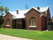
Lot 429 Mends St South Perth
Mechanics' Institute, Mends St Mall
Miss Burnet's School, Neeamara
South Perth
Metropolitan
Constructed from 1899
| Type | Status | Date | Documents |
|---|---|---|---|
| Heritage List | Adopted | 14 Nov 2000 | |
| State Register | Registered | 13 Aug 2004 | HCWebsite.Listing+ListingDocument, HCWebsite.Listing+ListingDocument |
| Type | Status | Date | Documents |
|---|---|---|---|
| (no listings) |
| Type | Status | Date | Grading/Management | |
|---|---|---|---|---|
| Category | ||||
| (no listings) | ||||
15843 South Perth Historic Village Precinct
| Name | Type | Year From | Year To |
|---|---|---|---|
| Henry James Prockter | Architect | - | - |
| Library Id | Title | Medium | Year Of Publication |
|---|---|---|---|
| 5145 | Old Mill theatre : Consvtn Plan & Theatre Refurb : formally The Mechanics Institute Hall at Mend Street behind 111 Mill Pt Rd South Perth, part of The South Perth Historic Village Precinct : conservation plan. | Heritage Study {Cons'n Plan} | 2000 |
Individual Building or Group
| Epoch | General | Specific |
|---|---|---|
| Other Use | GOVERNMENTAL | Town, Shire or District Hall |
| Original Use | EDUCATIONAL | Tertiary Institution |
| Present Use | SOCIAL\RECREATIONAL | Theatre or Cinema |
| Style |
|---|
| Federation Free Classical |
| Type | General | Specific |
|---|---|---|
| Roof | METAL | Zincalume |
| Wall | BRICK | Painted Brick |
| General | Specific |
|---|---|
| SOCIAL & CIVIC ACTIVITIES | Cultural activities |
| SOCIAL & CIVIC ACTIVITIES | Sport, recreation & entertainment |
This information is provided voluntarily as a public service. The information provided is made available in good faith and is derived from sources believed to be reliable and accurate. However, the information is provided solely on the basis that readers will be responsible for making their own assessment of the matters discussed herein and are advised to verify all relevant representations, statements and information.
Constructed from 1899
The following statement is drawn from the Heritage Council of Western Australia Register entry for the inclusion of Old Mill Theatre in the State Register of Heritage Places in 2004 Old Mill Theatre, a Federation Free Classical style painted brick and iron building, has cultural heritage significance for the following reasons: • the place and its landscaped grounds form part of a distinct and significant streetscape along Mends Street, and can be read as an integral component of the South Perth Historic Village Precinct; • the place is a modest but pleasing example of the Federation Free Classical style, designed by the architect Henry James Prockter; • the place, built in 1899, is representative of the development of Mechanics’ Institutes in Western Australia from the mid-nineteenth century, and is a rare as it was designed to accommodate the secondary function of Road Board Office; • the place is highly valued by the local community for its use as an amateur theatre from c.1946 to the present (2004); • the place is valued by the local community for its historic, educational and cultural associations, and contributes to the community’s sense of place through its prominent location in the administrative, commercial, entertainment and cultural centre of South Perth from 1899 to 2004; and, • the place is associated with people significant in the history of South Perth (and Western Australia) including May Gibbs, internationally renowned illustrator and author; Henry Prockter, architect; Thelma Jean ‘Jill” Hargrave, educationalist; and Constance Ord, theatre director.
The Mechanic’s Institute Hall fmr (Old Mill Theatre) is a detached single storey brick and iron Federation Free Classical style building incorporating classical ornamentation and distinctive parapeted gables to three elevations. The place consists of a large hall with parapeted gables to the north-east and south-west elevations. Two gabled wings extend from the hall in an easterly direction, connected by a timber framed and weatherboard link building (the south eastern wing and link building were constructed in the early 1970s) and two further gabled wings to the west elevation. Distinct round headed arched windows with coloured glass multi-pane highlight windows and plain glass multi-pane casements are positioned in each of the gables on the north west elevation, which is the principle elevation. The recessed door opening in the north west elevation continues the round headed arch window. The windows to the north east elevation are timber framed casements with multi-paned highlights and painted rendered lintels. Similar windows can also be found in the 1970s addition. The windows to the south west elevation (original hall) have been filled with brick and now read as blind openings. The main entry is on the north-east elevation via two doors: one leading into a foyer and one directly into the hall. The doors contain the same multi-pane coloured glass seen in the window openings. A small verandah connects the two wings on the main north-west elevation, the canopy of which is the continuation of the main roof, supported on timbered wall brackets. Both wings have timber four panelled doors opening onto the verandah with a further door to the rear of the verandah leads directly into a small lobby. The sprinkler valve enclosure fills much of the verandah area. The roof has been re-clad with colorbond. The building is set behind lawns with mature trees and planted garden beds. A bitumen roadway and parking extend along the south western side of the building and the rear elevation interfaces with Windsor Park.
The following information is largely drawn from the Heritage Council of Western Australia Assessment document prepared in for the inclusion of Place 2389 Old Mill Theatre in the State Register of Heritage Places in 2004. The growth of South Perth was slow until the 1880s, by which time access to Perth was improved with the introduction of ferry services and construction of bridges across the Swan and Canning Rivers. The discovery of gold in Western Australia from 1885 led to an increase in population, with land facing Perth Water progressively sub-divided between 1886 and 1904. It was during this period that much of the infrastructure of South Perth was developed. In 1892, the South Perth Roads Board District was formed, and, in 1902, the suburb became a municipality. By the turn-of-the-century there were four jetties at South Perth, the Zoological Gardens had opened (in 1898), and a school and postal facilities were established. What is now known as Old Mill Theatre was originally built as a Mechanics’ Institute Hall in 1899. The site in Mends Street was well-located for public access, due to easy access to ferry transport to the City from the Mends Street Jetty. Mechanics’ Institutes originated in Scotland in the early 1800s, to provide instruction for tradesmen, or ‘mechanics’, who may have received little or no formal education. By 1826, a similar institution had been established in London, and, by the 1850s, there were six hundred Institutes throughout England. Institutes were founded on the ideal of ‘improving’ the working classes. Mechanics’ Institutes, or Working Men’s Associations, were established in Western Australia during the nineteenth century. The Swan River Mechanics’ Institute, which was the first such organization in Western Australia, was founded in 1852. The South Perth Mechanics’ Institute trustees included local men; Arthur Douglas, Ernest C. Shenton, J.D. Manning, George E. Rogers and Henry James Prockter. In February of 1899, local architect and Institute Trustee Henry Prockter called for tenders to construct the South Perth Mechanics’ Institute Hall, as well as an attached office for the South Perth Road Board. Prockter had arrived in Western Australia from Victoria in 1896, and between then and 1904, carried out eighty-two building projects in Perth, including eleven in South Perth. Buildings that he designed in South Perth included St Mary’s Church (1898) and a Shelter Shed on the Mends Street Jetty (1901). On 23 May 1899, a meeting of the members of the Institute was held at the Windsor Hotel, to approve borrowing against the land that the Hall was to be built on, and which the Institute owned, in order to finance the building of the premises, which were, in fact, almost completed. A few weeks later, the Trustees advised the Colonial Under-Secretary that £500 had already been raised by mortgaging the property to local businessman and entrepreneur, Joseph Charles, and that the building was already completed, with the builder awaiting payment. The completed Hall was opened by Sir John Forrest on 7 August 1899. According to an account of the opening night in the West Australian, the building was a 'substantially-built hall, with offices of neat design’. The Hall was used for concerts, as well as providing a library and billiards parlour. Immediately after the official opening of the Hall, a ‘high class concert’ was held, with solo performances contributed by May Gibbs and S.W. Copely, followed by a comic play, ‘To Oblige Benson’. Negotiations were entered into by the South Perth Municipal Council to buy the hall in 1903, but when discussions failed, the Council commenced construction of their own premises at the corner of Mill Point Road and Mends Street, South Perth immediately to the north of the Mechanics’ Institute Hall (see South Perth Road Board Offices MPt13). The Mechanics’ Institute Hall was the venue of a number of private schools for the children of middle class South Perth families. Despite this and other sources of income, by 1908 the Institute was in decline. On 25 November 1912, the Annual Meeting of Ratepayers raised the possibility of Council taking over the Mechanics’ Hall. After endorsement by ratepayers at a Special Meeting on 9 April 1913, a month later Council resolved to raise a loan of £1000 to purchase the hall and the Institute's other assets. After acquiring the Hall soon afterwards, the Council renamed the building the Mends Street Hall on 18 December 1913, and continued to rent the Hall for educational use. From 1913 until 1918, Miss A.E. Binsted’s ‘South Perth High School’ operated from the Hall. It was sometime during 1918, that a group of local parents, who for reasons now unknown were unhappy with Miss Binsted’s management of the South Perth High School, established a rival school in St Mary’s Hall. Miss Agnes Cross, the retired headmistress of Tintern School, in Victoria, was brought to South Perth, to set up the new school. Within a short time, most of the Miss Binsted’s students had gone across to Miss Cross’s establishment. Miss Binsted moved out of the Institute Hall, which was now taken over by Miss Cross. South Perth High School was renamed Raith Girls’ Grammar School, although boys also attended the school. Miss Cross’ sister, Pearl, who was in charge of boarders at Cowandilla School, West Perth (later St Mary’s School), joined Raith as Head of a new boarding school. The Boarding House was first established in the home of the Gibbs family, in Harvest Terrace, who were, at the time, in England. Later, the boarders lived in Professor Walter Murdoch’s house in Mill Point Road. From 1923 until 1928, Raith Girls’ Grammar School was funded by the Church of England, and underwent a change of name to Raith Church of England Girls’ Grammar School. The school, now with eighty pupils, four teachers, and three boarders, was managed by Miss Marjorie Broadhurst. Between 1929 and 1933, the again renamed Raith Girls’ Grammar School was run by Miss Hetherington. The older girls had left by this time, for Perth College, St Mary’s and St Hilda’s, leaving only the younger children (which still included boys) to be taught. Between 1934 and 1935, Raith School was directed by Miss Jill Hargrave. From 1935, Raith Grammar School became known as St Ann’s Kindergarten and Junior School and operated under Miss Hargrave’s direction. The school was registered as a kindergarten and a sub primary, and an extra teacher was employed. However, as Miss Hargrave felt constrained by the lack of opportunity for expansion at the Mends Street Hall she sought land to establish a larger school. By 1940, the school had moved to new premises in Angelo Street and the Mends Street Hall continued to be used for community purposes. From 1946, the Mends Street Hall was the venue for concerts and plays organised by local groups. In May 1948, the South Perth Dramatic Club was formed and they held there first performance in October 1948. The first committee included Constance Ord (1918-2010) who held roles at the club from 1948 to 1999 and was a driving force in the development of the club, the venue and theatre in Western Australia. In the early 1960s, other venues became available in South Perth so that the South Perth Dramatic Club was able to request in 1963 they take on the lease of the building for a nominal fee to transform it into a 'Little Theatre'. Soon afterwards, the South Perth Dramatic Club was renamed the ‘Old Mill Theatre’, which also became the name of the old Mends Street Hall, where the group rehearsed and performed. The hall was still available for use by other community groups. Improvements paid for by the Theatre company include fixed seating in raised rows, heating, installation of ceiling fans, and carpeting of the audience space. The foyer and Club Lounge were lined with solid wood panelling, fully carpeted, and lit with chandeliers. In 1973, the South Perth City Council built an addition to Old Mill Theatre, which provided much needed dressing room and storage facilities. Further renovation was needed after a fire in 1984 caused extensive damage to parts of the Theatre. In 1989, the City of South Perth honoured Constance Ord with a medal for her contribution to the South Perth community, and especially her work with the Old Mill Theatre from the late 1940s to the 1980s. In 2002, the Theatre building underwent further substantial restoration work, including work to its exterior to remove the painted finish from the outer walls and bring it back, as closely as possible, to its former appearance with a red brick façade.
Moderate / High
Good
| Name | Type | Year From | Year To |
|---|---|---|---|
| Henry James Prockter | Architect | - | - |
| Reserve | Lot/Location | Plan/Diagram | Vol/Folio |
|---|---|---|---|
| 444 | 166964 | LR3060-644 |
This information is provided voluntarily as a public service. The information provided is made available in good faith and is derived from sources believed to be reliable and accurate. However, the information is provided solely on the basis that readers will be responsible for making their own assessment of the matters discussed herein and are advised to verify all relevant representations, statements and information.
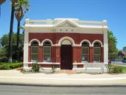
111 Mill Point Rd South Perth
Roads Board Building
South Perth Heritage House
South Perth
Metropolitan
Constructed from 1904 to 1977
| Type | Status | Date | Documents |
|---|---|---|---|
| Heritage List | Adopted | 14 Nov 2000 | |
| State Register | Registered | 02 Jul 1999 | HCWebsite.Listing+ListingDocument, HCWebsite.Listing+ListingDocument |
| Type | Status | Date | Documents |
|---|---|---|---|
| (no listings) |
| Type | Status | Date | Grading/Management | |
|---|---|---|---|---|
| Category | ||||
| (no listings) | ||||
15843 South Perth Historic Village Precinct
| Name | Type | Year From | Year To |
|---|---|---|---|
| Duncan Inverarity | Architect | - | - |
| Library Id | Title | Medium | Year Of Publication |
|---|---|---|---|
| 9608 | Conservation plan: heritage house, South Perth. | Heritage Study {Cons'n Plan} | 1996 |
Individual Building or Group
| Epoch | General | Specific |
|---|---|---|
| Present Use | HEALTH | Other |
| Original Use | GOVERNMENTAL | Town, Shire or District Hall |
| Style |
|---|
| Federation Free Style |
| Type | General | Specific |
|---|---|---|
| Wall | BRICK | Common Brick |
| Roof | METAL | Zincalume |
| General | Specific |
|---|---|
| OCCUPATIONS | Commercial & service industries |
This information is provided voluntarily as a public service. The information provided is made available in good faith and is derived from sources believed to be reliable and accurate. However, the information is provided solely on the basis that readers will be responsible for making their own assessment of the matters discussed herein and are advised to verify all relevant representations, statements and information.
Constructed from 1904
The following statement is drawn from the Heritage Council of Western Australia Register entry for the inclusion of Old Council Officers in the State Register of Heritage Places in 1999. Old Council Offices, a single storey brick and iron building in the Federation Free Style has cultural heritage significance for the following reasons: • the presence of the place contributes towards, and forms part of, a historic group of buildings at the junction of Mends Street, Mill Point Road and Labouchere Road; • the place has associations with the development of the suburb of South Perth and reflects the attitudes of the period when Road Board Offices were a public expression of civic pride; • the place has associations with the adjacent Old Mill Theatre (formerly Mechanics Institute, 1899), both of which represent the development of the local government in South Perth; and, • the place has social significance for the residents of South Perth who wished the building to be returned to the rate payers for their use as a repository for heritage records and research.
The South Perth Roads Board building) is a single storey brick building in the Federation Free Classical architectural style. The front section of the building has been finished with tuck-pointing and further enhanced by the cream painted rendered classical detailing to the façade including parapet, pediment, window arches, pilasters and plinth. A rendered string course extends along the side elevations, continuing to the lintels and sills. The original galvanised corrugated iron roof has been replaced with zincalume, long length sheets. The building presents in three sections: the front section which formed the Council Office; the central section located behind and is slightly narrower which was the Council Chamber; and the rear section which has a wider plan form than the former Chambers which was constructed in the 1930s to similar detailing as the original two sections of the building. The façade faces Mill Point Road and due to the surrounding open space, makes a striking contribution to the streetscape. The façade presents in a symmetrical manner with centrally positioned double timber doors with solid arched fanlight above. The doors are flanked by pairs of 1-over-1 timber framed sash windows with arched fanlights. The rendered sills to the windows form a continuous low level band to the two sections of the façade. The five arched openings create a strong rhythm to the façade. The rendered corner pilasters frame the façade and extend from ground level to the balustrade parapet which further frames the front elevation. The entrance bay projects marginally from the remainder of the façade and is given further prominence by the decorative pediment above the opening, which integrates into the parapet. The parapet wall wraps around the side elevations, gradually reducing in height to the main building height with opposing curved wall capping elements. The side elevations of the former Council Chambers continue the tuck pointing and rendered finish but the windows are multi-paned frosted glass casements rather than double hung sash windows. The 1930s rear section is also tuck pointed with a rendered band around the openings. Each of the three sections of building incorporates a separate roof form, albeit all gabled roofs clad in zincalume. The front section of roof is hidden from view by the parapet wall when viewed from Mill Point Road but is clearly visible in the side profile views. The ridge of the front section of roof sits well below the central section of roof. The rear section is a much lower roof with shallower pitch. A single brick chimney is positioned at the north eastern edge of the central section of the building, with tuck pointing to the brickwork and decorative rendered corbelling to the flue. Recent landscaping surrounds the building.
The following information is largely drawn from the Heritage Council of Western Australia Assessment document prepared in 1999 for the inclusion of Old Council Offices in the State Register of Heritage Places. When the South Perth Road Board was first formed in 1892, members met in each other’s houses, along Mends Street and Suburban Road (later re-named Mill Point Road). In 1889, the Mechanics’ Institute Hall was built, and Road Board meetings were held in rooms rented in the new building. A decision was made in October 1903 to build offices for the Road Board. Plans were drawn up by local architect and Council Surveyor, Duncan Inverarity, and the successful tenderer was local builder, Frederick Stidworthy. Fred Stidworthy was a first class stone mason and was commissioned to design and construct the stone work at the zoo. From there he went on to do the stone work at the Perth Museum. The plans for the new Road Board Offices were expanded to include a meeting chamber, and the first meeting was held in the new building on 17 November 1904. A strong room was installed in March 1914, and minor renovations were carried out by G B Puttlich & Son during World War I. When the offices became crowded, two additional rooms were added at the rear of the building in 1937. By the 1950s, the Road Board Offices had become dilapidated and the inadequacy of office space was still a problem. Progress towards a new civic centre was finally made in 1959, the year the South Perth district became a City. The foundation stone for a new civic centre in South Terrace was laid in May 1959, and the building was opened by the Premier, David Brand, on 10 December 1960. With the establishment of a new Civic Centre, the South Perth Road Board Offices (Fmr) and the Mends Street Hall (former Mechanics Institute) were no longer required for civic use. The South Perth Road Board Offices (Fmr) were initially rented by a security firm until 1977, after which the building became a medical surgery. In 1989, a decision was made to use the South Perth Road Board Offices (Former) as a centre for historical research by the local community. Extensive repairs were carried out, and on 7 June 1992, the building was rededicated as ‘South Perth Heritage House’. It was staffed by the Local Studies Librarian as a resource centre for local history, and was also used as a meeting place for relevant community groups including the South Perth Historical Society. The building is also used to exhibit art collections from time to time, and is home to the May Gibbs art collection owned by the City. A notable feature of the building is the large strong room which is useful in holding a valuable collection of historical photographs and original documents. Following completion of major renovations and expansion of the Civic Centre Library, the City’s local studies records and officers vacated Heritage House and relocated to the Civic Centre Library. On 1 July 2013, the South Perth Historical Society commenced a lease of the premises and continue to occupy the place which is also used as a gallery space and cultural centre for the City of South Perth.
Moderate / Moderate
Good
| Name | Type | Year From | Year To |
|---|---|---|---|
| Duncan Inverarity | Architect | - | - |
| Ref ID No | Ref Name | Ref Source | Ref Date |
|---|---|---|---|
| David Kelsall "Architectural Assessment" | Heritage Architect | 1999 |
| Reserve | Lot/Location | Plan/Diagram | Vol/Folio |
|---|---|---|---|
| 28021 | 444 | 166964 | LR3060-644 |
This information is provided voluntarily as a public service. The information provided is made available in good faith and is derived from sources believed to be reliable and accurate. However, the information is provided solely on the basis that readers will be responsible for making their own assessment of the matters discussed herein and are advised to verify all relevant representations, statements and information.
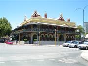
112 Mill Point Rd South Perth
Cnr Mends Rd
South Perth
Metropolitan
Constructed from 1898
| Type | Status | Date | Documents |
|---|---|---|---|
| Heritage List | Adopted | 14 Nov 2000 | |
| State Register | Registered | 27 Feb 1996 | HCWebsite.Listing+ListingDocument, HCWebsite.Listing+ListingDocument |
| Type | Status | Date | Documents |
|---|---|---|---|
| (no listings) |
| Type | Status | Date | Grading/Management | |
|---|---|---|---|---|
| Category | ||||
| Register of the National Estate | Indicative Place | |||
| Register of the National Estate | Nominated | 21 Dec 1990 | ||
| Statewide Hotel Survey | Completed | 01 Nov 1997 | ||
| Classified by the National Trust | Classified | 04 Sep 1989 | ||
15843 South Perth Historic Village Precinct
| Name | Type | Year From | Year To |
|---|---|---|---|
| J J Talbot Hobbs | Architect | - | - |
Individual Building or Group
| Epoch | General | Specific |
|---|---|---|
| Other Use | EDUCATIONAL | Other |
| Original Use | COMMERCIAL | Hotel, Tavern or Inn |
| Present Use | COMMERCIAL | Hotel, Tavern or Inn |
| Style |
|---|
| Federation Filigree |
| Type | General | Specific |
|---|---|---|
| Wall | BRICK | Common Brick |
| Roof | METAL | Corrugated Iron |
| General | Specific |
|---|---|
| OCCUPATIONS | Hospitality industry & tourism |
This information is provided voluntarily as a public service. The information provided is made available in good faith and is derived from sources believed to be reliable and accurate. However, the information is provided solely on the basis that readers will be responsible for making their own assessment of the matters discussed herein and are advised to verify all relevant representations, statements and information.
Constructed from 1898
The following statement is drawn from the Register Entry for Place 2392 Windsor Hotel prepared in 1995. Windsor Hotel has cultural heritage significance for the following reasons: • the place is representative of the Australian pub tradition as a two storey hotel with verandahs, located on a prominent street corner; • the place is a fine example of Federation Filigree Style; • the place is a landmark in the townscape of South Perth; • the place is closely associated with the early development of suburban housing south of the river in the late 1890s; and, the place is a fine example of the commercial architecture of J.J. Talbot Hobbs, one of Perth's prominent architects of the 1890s.
The Windsor Hotel, prominently located at the intersection of Mends Street and Mill Point Road, is an important component of the Mends Street heritage precinct. The building was sited to take advantage of the patrons visiting the Perth Zoo whose journey included a ferry trip across the Swan River. The intact street verandah is scarce in suburban Perth, particularly with intact cast iron lace and columns. The two storey Windsor Hotel building, designed by architect J J Talbot Hobbs and constructed in 1898, is a good example of Federation Filigree style combining Italianate details with decorative cast iron filigree verandahs. The building is constructed with tuck-pointed brickwork in Flemish bond and its corrugated iron roof is concealed behind a parapet. The verandah and balcony extend along both street façades and are covered with a lean-to roof. The verandah roof is broken by gables which highlight the main entrance to each street façade and the truncated corner. The verandah roof is supported on fine, ornamental cast iron posts with capitals and cast iron balustrading. The truncated façade is also rendered. At the lower level, the windows are plain arched sash windows, recessed behind the outer face of the building. They are connected at their springing point by brick ornamental arched mouldings. The rendered and painted brick street dado wall, dividing the al fresco area from the public footpath, is visually intrusive and conceals the foundation of the verandah columns. It provides a severe line of demarcation and its removal should either be encouraged or alternatives sought. The main entry to the Windsor Hotel is located off Mill Point Road. The double door entrance has a rendered masonry arch surround with leadlight fanlights and side lights of clear glass. Since 1962, there have been a series of alterations and modernisations to the original hotel.
The hotel was built for George Thomas Strickland (c1859-1947) by architect, Joseph John Talbot Hobbs (1864-1938) and the contract, let in April 1898, was worth £4,050. Shortly after the opening, Strickland passed the management of the hotel over to his nephew, William Henry James Strickland (1862-1940). The name of the hotel was likely to have been a dedication to the family name of the British Royal Family. Hobbs gained his architectural training in England, and arrived in Western Australia in 1887. He soon established a reputation as one of Perth's finest architects. His early commissions include, Christ Church, Claremont (1892), the Weld Club, Perth (1892) and the Swan Brewery, Perth (1897). He designed many large residences for wealthy colonists who prospered during the gold boom period including, Haddon Hall, South Perth (1897); Walter James' Minnawarra (1899); and, his own residence, the Bungalow (1904). Hobbs later had a distinguished military career serving as Lieutenant General during the First World War and was knighted for his service. The opening of the Windsor Hotel came at a time when the popularity of South Perth was increasing. From the mid-1880s, there was slow but appreciable growth in the number of residents in South Perth and within ten years it had become a well established suburb. After the mid-1890s a speculative element entered into the sale of South Perth suburban land. Some of the larger sections were bought for the purpose of quick sub-division and sale to take advantage of rising prosperity and the prospect of ferry or bridge communication being established with Perth. In 1892, the South Perth Roads Board District was formed. By the turn-of-the-century there were four jetties at South Perth, and boats were the chief means of communication with the city. By the end of the 1890s South Perth was progressing, and a number of substantial facilities were being developed. The Zoological Gardens opened in October 1898, a school opened and postal facilities were established. As the area developed rapidly, some public facilities were not able to be built quickly enough and for a short while the Windsor Hotel served as the Post and Telegraph Office, which operated from a room at the foot of the stairs with Miss Theresa O'Dea as Postmistress. This arrangement would have been facilitated by the owner of the Windsor Hotel, George Strickland who had strong ties to the Post and Telegraph Services as he previously held the position of Deputy Superintendent of Telegraphy in the colony. A lengthy description of the Windsor Hotel in January 1899 shortly after its opening stressed the picturesque locality with access to breezes making the hotel a delightful resort. At that time the hotel included the entry hall, public bar, a large dining room to accommodate 100 diners, post and telegraph office, commercial room, billiard room, private bar, drawing room on the first floor, two bridal chambers, nine single bedrooms, bathrooms and lavatories for ladies and gentlemen, and broad and expansive balconies. George Strickland owned all the land on the eastern side of Mends Street between the Esplanade and Suburban Road and built a large home facing the Esplanade at the same time he built the Windsor Hotel. Strickland offered the Windsor Hotel for auction in 1924; but was not in fact sold until 1929 when it was purchased by Mary Thomas, later the well known hotel owner Mary Raine for £25,000. Management of the Windsor Hotel was transferred to Jack and Dora Carter who held the license until 1945. Later licensees were Cole and Meg Sangster. The Sangsters retained the lease of the Windsor Hotel for ten years after Mary Raine bequeathed the Windsor Hotel and several other properties to the University of WA in 1957. Since 1962, there have been extensive additions, alterations, and some remodelling, that have taken place. The number of patrons had been steadily increasing since the opening of the Narrows Bridge. Three architectural firms in particular have been involved in additions and alterations to the place; Cameron Chisholm & Nicol (1962, 1965, 1970), Oldfield Knott (1980s) and Oldham Boas Ednie-Brown (1980, 1991). The major works were carried out in 1962, 1965, and 1970. In 1998, Mr Geoffrey Ogden, the former Licensee, purchased the hotel from the University of Western Australia (Raine Foundation). Since that time the hotel has continued to be well maintained, adapted and upgraded in response to changing standards and customer expectations.
Moderate
Good
| Name | Type | Year From | Year To |
|---|---|---|---|
| J.J. Talbot Hobbs | Architect | - | - |
| Reserve | Lot/Location | Plan/Diagram | Vol/Folio |
|---|---|---|---|
| 100 | 39529 | 323-2A |
This information is provided voluntarily as a public service. The information provided is made available in good faith and is derived from sources believed to be reliable and accurate. However, the information is provided solely on the basis that readers will be responsible for making their own assessment of the matters discussed herein and are advised to verify all relevant representations, statements and information.
130 Mill Point Rd South Perth
La Petite Noir
Ladislav's Restaurant
South Perth
Metropolitan
Constructed from 1902, Constructed from 1900
| Type | Status | Date | Documents |
|---|---|---|---|
| Heritage List | Adopted | 14 Nov 2000 | |
| State Register | Registered | 15 May 1998 | HCWebsite.Listing+ListingDocument, HCWebsite.Listing+ListingDocument |
| Type | Status | Date | Documents |
|---|---|---|---|
| (no listings) |
| Type | Status | Date | Grading/Management | |
|---|---|---|---|---|
| Category | ||||
| (no listings) | ||||
15843 South Perth Historic Village Precinct
Individual Building or Group
| Epoch | General | Specific |
|---|---|---|
| Present Use | COMMERCIAL | Restaurant |
| Original Use | RESIDENTIAL | Two storey residence |
| Style |
|---|
| Other Style |
| Type | General | Specific |
|---|---|---|
| Roof | TILE | Terracotta Tile |
| Wall | BRICK | Common Brick |
| General | Specific |
|---|---|
| PEOPLE | Famous & infamous people |
| SOCIAL & CIVIC ACTIVITIES | Community services & utilities |
This information is provided voluntarily as a public service. The information provided is made available in good faith and is derived from sources believed to be reliable and accurate. However, the information is provided solely on the basis that readers will be responsible for making their own assessment of the matters discussed herein and are advised to verify all relevant representations, statements and information.
Constructed from 1900
The following statement is drawn from the Heritage Council of Western Australia Register entry for the inclusion of Stidworthy Residence (fmr) in the State Register of Heritage Places in 1997. Stidworthy Residence (fmr), a two-storey brick and tile residence with a timber framed street facade at first floor level, has cultural heritage significance for the following reasons: • the place has aesthetic value for its unusual and eclectic design; • the place is significant as a substantial addition to the built landscape of the developing municipality of South Perth at the turn of the century, and for its close association with the history of Perth Zoological Gardens; • the shop is the only remaining example of a number of ‘tearooms’ which were popular in the area; it is a representation of the recreational habits of Perth residents at this time; • the place has retained a clear sense of its original mixed-use function and represents the way of life of a particular class of people in Perth in the early twentieth century; • the place has landmark value within South Perth due to its prominent location and open situation on the corner of Mill Point Road and Darley Street; • the place has streetscape value for its proximity to other historic buildings and the prominent mature palm trees on the site; and, the place is representative of the work of its original owner, designer and builder who was a figure of some local prominence in his field.
The Stidworthy Residence and Tearooms (Former) is a local landmark due to its distinctive architectural style, prominent location along Mill Point Road and mature palm trees to the corner of the site. The former Stidworthy Residence is a distinctive two-storey building with no setback from the Mill Point Road boundary. There is symmetry to the façade with a recessed centrally located entrance door flanked by full height windows. The upper level contains two 3-section timber framed casement windows and balcnies down both sides connected by a canopy across the façade, supported on prominent curved brackets. The upper floor roof overhangs the ground floor supported on solid masonry columns of the Tuscan order. The side balconies have timber balustrades and posts. The building is of rendered brick construction to the majority of the structure with the overhang being clad with scalloped edge timber weatherboards. The masonry walls behind the timber section rise to form a parapet wall which hides a low pitched roof.
The Stidworthy Residence and Tearooms (Fmr), situated on the corner of Mill Point Road and Darley Street, South Perth was designed and constructed in c1901-1902 by its owner, Mr Frederick Stidworthy, a local South Perth builder/contractor and stone mason. The site forms part of the land originally granted to William Fisher Mends. Most of the property was subsequently purchased by Supreme Court Judge, Sir Edward Albert Stone, who sold portion of it to Charles Darley on 26 June 1892. Darley subdivided the land and sold Lot 5 to Frederick Stidworthy (c1858-1918) on 1 April 1900. Stidworthy and his wife, Lucy, and their eight children had moved from New South Wales to Perth around 1900 at the suggestion of Ernest Le Souef, who was the Director of the new Zoological Gardens at South Perth. Stidworthy designed and built all the early stonework at the Zoological Gardens, including the cave-like bear pits. In mid 1900, Frederick Stidworthy advertised for a labourer to undertake plastering work and a carpenter for a project opposite the zoo. In November 1900, he advertised for a tuck pointer for a project opposite the Zoo. This information indicates the residence was constructed in 1900. In February 1901, Frederick Stidworthy applied for an Eating House licence 'for the shop or rooms which I now occupy, or intend to occupy, situated opposite the Zoological Gardens, Suburban Road South Perth and known as the Refreshment Rooms; now holding a temporary licence'. After the Stidworthys moved into their family home, they catered for boarders, and from 1902 until 1918, Lucy Stidworthy operated tea rooms from the shop front of the building. This was in the early years of the Zoological Gardens, when the Zoo entrance was located in Suburban Road opposite. In 1906, the property was transferred to Lucy Stidworthy. On 15 July 1918, Frederick Stidworthy died after being stabbed in an altercation at or near the City Hotel, in Barrack Street, Perth. The Stidworthy family continued to live at this address until 1935. The building was then leased to Mr John Randall, a hotel keeper, for five years. Mrs M E Randall rented out apartments within the property. During World War II, members of the Stidworthy family moved into the ‘maid’s quarters’, a timber structure which had been situated at the rear of the block. City records show that a building licence for a laundry and wash house was issued in 1958. This outbuilding was demolished in 1996. The property was in the ownership of various members of the Stidworthy family from 1900 to 1952, and rooms were rented to a number of people over the years, including from 1938 to 1941 to a Miss P Hafferen, who was listed in Wise’s Post Office Directories for these years as a dressmaker. In 1952, the property was sold to Mr Pietro Nunziato Corica, storekeeper, and Joseph Corica, tailor. The property remained in the Corica family until 1993, when it was sold to overseas purchaser, Efendi Kusnadi Khoe and Fong Lan Tjhin of Indonesia. In December 1963, the Council considered a report by the City’s Senior Health Inspector, regarding the unauthorised use of portion of the building as a boarding house. At that time, the premises consisted of three flats and a café. Two of the flats were above the café, and one of these was legitimately rented. The remainder of the building was rented by Mr Marcos Dindic. The shop front was used as a café and served meals prepared in the kitchen of the downstairs flat which was occupied by Mr Dindic. The other upstairs flat was let by Dindic to boarders, with five beds available for use. In 1979, a French-style restaurant, Le Petit Niçois, opened, and operated for at least ten years, followed by Ladislav’s Restaurant until June 1993. After this the building was vacant and was badly damaged by squatters and vandals. In October 1996, the City of South Perth was contacted by Philip Pendal MLA, who urgently requested the City to take steps to ensure the restoration and protection of the building. Fred Stidworthy’s granddaughter, Mrs Rhonda McDonald, was also supportive. Despite threat of legal action no restoration work was undertaken by the owners and in December 1996 the City of South Perth declared the building to be unfit for human habitation. Concurrently, the Heritage Council of Western Australia undertook an assessment of the place for possible listing in the State Register of Heritage Places. The building was permanently registered on 15 May 1998. In October 1997, the Council approved major renovations and the building was extensively restored to operate as a restaurant. A structural report undertaken at the time confirmed that the building was basically sound despite the damage from squatters. The building was reroofed, re-plumbed, rewired and reglazed. Terracotta cobble stones and floor tiles were imported from Mexico for the courtyard and ground floor. The upstairs floorboards and jarrah staircase were repaired and the damaged or missing balustrades were replaced with timber turned to match the original pieces; and new doors and window frames were made from red cedar to match the original frames. The refurbished restaurant was named Habanero, after a chilli from Mexico’s Yucatan Peninsula, and this was Perth’s first Latino restaurant. The restaurant occupied the full ground and upper floors of the building, using the several small rooms as separate dining areas, with some alfresco dining in the forecourt. The restoration works included the construction of a 10-bay car park at the rear. The landmark palm trees growing along the Darley Street frontage were also retained, although some were required to be relocated. Some internal walls were removed to enlarge the main dining area, with ‘drop panels’ retained as evidence of the location of the former walls. Some windows were also bricked up, while others were created and new double-width doors were opened at the ground floor for better access to the alfresco areas. From about 2001, the restaurant has operated as Soprano’s Pizzeria Ristorante. At that time, a new dome-shaped masonry pizza oven was built on the exterior of the eastern wall, along with weather protection for an alfresco dining courtyard along the Darley Street frontage.
Moderate / Moderate
Good
| Ref ID No | Ref Name | Ref Source | Ref Date |
|---|---|---|---|
| Heritage Council of WA Assessment | 1997 | ||
| City of South Perth Municipal Heritage Inventory | City of South Perth | 1994 | |
| Research by Lise Summers, former City of South Perth Local Studies Librarian | City of South Perth |
| Reserve | Lot/Location | Plan/Diagram | Vol/Folio |
|---|---|---|---|
| 5 | 982 | 1332-113 |
This information is provided voluntarily as a public service. The information provided is made available in good faith and is derived from sources believed to be reliable and accurate. However, the information is provided solely on the basis that readers will be responsible for making their own assessment of the matters discussed herein and are advised to verify all relevant representations, statements and information.
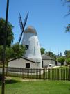
Lot 818, 833 Mill Point Rd South Perth
Address includes: Lot 833 Melville Pl, South Perth & Lot 818 Mill Point Rd, South Perth. VFL - 9/12/2010.
Shenton's Mill
South Perth
Metropolitan
Constructed from 1837
| Type | Status | Date | Documents |
|---|---|---|---|
| Heritage List | Adopted | 14 Nov 2000 | |
| State Register | Registered | 02 Jul 1993 | HCWebsite.Listing+ListingDocument |
| Type | Status | Date | Documents |
|---|---|---|---|
| (no listings) |
| Type | Status | Date | Grading/Management | |
|---|---|---|---|---|
| Category | ||||
| Register of the National Estate | Permanent | 21 Mar 1978 | ||
| Flour Mills Survey | Completed | 30 Jun 1994 | ||
| Classified by the National Trust | Classified | |||
| Library Id | Title | Medium | Year Of Publication |
|---|---|---|---|
| 6752 | South Perth : the vanishing village. | Book | 2003 |
| 7626 | Old Mill Precinct concept proposal brief for adaptive heritage re-use & revitalisation for sustainability : presented for public consultation by Adaptive Heritage Pty Ltd. | Report | 2005 |
| 65 | The Old Mill South Perth: conservation plan. | Heritage Study {Cons'n Plan} | 1993 |
| 6039 | Investigating the old mill : a teacher resource book and student workbook (draft). | Report | 1996 |
| 324 | Western Australia An architectural heritage | Book | 1979 |
Individual Building or Group
| Epoch | General | Specific |
|---|---|---|
| Present Use | EDUCATIONAL | Museum |
| Other Use | COMMERCIAL | Hotel, Tavern or Inn |
| Other Use | RESIDENTIAL | Other |
| Other Use | FARMING\PASTORAL | Other |
| Original Use | INDUSTRIAL\MANUFACTURING | Flour Mill |
| Style |
|---|
| Other Style |
| Type | General | Specific |
|---|---|---|
| Wall | STONE | Local Stone |
| General | Specific |
|---|---|
| OCCUPATIONS | Manufacturing & processing |
This information is provided voluntarily as a public service. The information provided is made available in good faith and is derived from sources believed to be reliable and accurate. However, the information is provided solely on the basis that readers will be responsible for making their own assessment of the matters discussed herein and are advised to verify all relevant representations, statements and information.
Constructed from 1835
• The place has aesthetic value as a rare example of a stone and shingle industrial structure built in the 1830s in good condition. • The place has aesthetic value as a landmark in the wider Perth metropolitan area in a prominent location. • The place has historic value as one of the first wind driven flour mills in the state and demonstrates the early attempts of establishing industry and commerce in the community. • The place has historic value for its association with early settlers and landowners; William Kernot Shenton and Edward Hamersley; local tradesmen, Paul and James Lockyer and William Steel; and entrepreneur, Thomas Satan Brown. • The place has research value for its remaining elements and structure demonstrating wind driven mills in the early 19th century • The place has social value for the community as demonstrated by the community resolve to save it from destruction in the 1950s when threatened by the construction of the Narrows Bridge. • The place has social value as a place for education since the 1950s when it was developed as a museum which has been accessed by local, interstate and international visitors.
The Old Mill and Cottage (Former), is situated on the promontory of Point Belches in South Perth, alongside the Narrows Bridge. The Old Mill is a traditional circular, stone structure, which has been plastered and painted / lime-washed, and tapers from the base to the tip of the shingled cap. The Mill is approximately 5.0 metres in diameter at the base, and 3.0 metres diameter at the roof line, with walls 600mm thick at the base and 450mm thick at the top. The wall height of the Mill is 8.0 metres over three storeys, with a 2.5 metre high roof above. A single storey entry building sits at the base of the southern aspect of the Mill, of similar painted limestone construction with gabled roof, clad with timber shingles. Small timber framed windows are placed at varying heights around the Mill with the loading doors on the west elevation, under the sales. The roof of the Mill consists of a timber-framed cap sheeted externally with timber shingles without overhang or gutters. The cap dates from the 1957-59 restoration undertaken following its threat of demolition. The sales also date from this restoration phase. Internally, the Mill has a contemporary concrete floor slab, housing the mechanism which supports and turns the sails. The mechanism is electrically driven. A modern wooden ladder leads to the cap level. There is a timber-framed window in the northern wall and two heavy timber ceiling beams remain from the original structure. The middle level houses mill grinding machinery relocated from Chapman’s Mill in Busselton. It has three timber-framed windows and a door in the northern wall. Heavy timber beams in the ceiling supported the machinery above. The ground level has doorways in the northern and southern walls and three heavy timber beams in the ceiling to support the machinery above. The single storey room to the south elevation of the Mill has been reduced in size and now measures 5m x 2m. A door in the southern wall of the Mill provides access to the room. The floor is concrete and the walls, much altered, are painted stonework. Two small windows in the eastern and western walls provide some light, with a slightly larger window in the southern wall. The roof comprises low pitched timber framing lined internally with painted metal sheeting with external timber shingles. This roof is a reconstruction dating from 1957-59 and since further restored. The cottage, located approximately 8.5m to the north of the Mill, is a single storey brick building, measuring 12.5 x 6.0 metres. The building contains a main room with an open fireplace, with two smaller rooms leading off from the main space. A skillion-roofed kitchen at the northern end of the cottage is accessed through one of the small rooms. An open fireplace and bread oven project out from the northern wall of the kitchen. Both external and internal walls of the cottage have been rendered and painted. The external roof covering is replacement timber shingles. Floors throughout the Cottage are oiled timber boarding, some original. Windows and doors are timber, but not original. A timber framed awning protects the main entrance door in the western wall. A small detached facilities block has been constructed to the north east corner of the Cottage and a 1980s building constructed to the south of the Mill used as an education centre. The grounds are predominantly lawn, populated with mature trees, with a timber picket fence around the Mill and Cottage.
The Mill component of the Old Mill and Cottage (Former) was the second Mill built by William Kernot Shenton on 4½ acres (1.8 ha) of land granted to him in April 1833. The present Mill was built in 1835 by millwrights, Paul and James Lockyer, and was operated by miller, William Rolf Steel, the business partner of William Shenton. The Mill was developed on Point Belches because of its proximity to the Perth central business district and water transport between Fremantle and Guildford. ‘Miller’s Pool’, a large basin of water to the east of the Mill, had a 12.0 metre wide mouth to the river, and was then deep enough to provide mooring for small boats servicing the Mill. At its peak, the wind-driven mill produced 680 kg of flour per day. William Shenton sold the mill in 1840 to Edward Hamersley and the mill continued to operate under lease from Hamersley who had a house to the east of the mill. However, the Mill did not prove to be profitable, and stopped production in 1859. During this period a small brick cottage was built to the north of the Mill. In 1870, South Perth resident, Thomas Satan Brown leased the buildings and converted them into a hotel and picnic ground called the ‘Alta Gardens’. He added verandahs to encircle the Mill and a viewing platform on the top. The project did not succeed and the site was later used as a residence, wine saloon and poultry farm until resumed by the Government in 1929 from the owner Walter Green to mark the centenary of Foundation. In the late 1950s, the Old Mill and Cottage (Fmr) were threatened with demolition by the construction of the Kwinana Freeway, but were saved due to the intervention of local residents, the historical society and the Minister for Works, John Tonkin. The Old Mill and Cottage (Fmr) were granted to the City of South Perth to commemorate the centenary of the founding of Local Government in South Perth in 1892. The buildings and site were repaired and upgraded by Brisbane and Wunderlich and maintained as a folk museum from 1957 until vested in the National Trust in 1992. In 1994-95, the Old Mill was restored to a close approximation of its appearance in the 1830s. The verandahs surrounding the mill were removed and the cottage’s corrugated iron roof cladding was replaced with shingles. In February 2017, the reinstated Miller’s Pool was opened by the City of South Perth Mayor. The project was part of a wider strategy of foreshore works with a strong focus on sustainable design and indigenous associations with the site. The urban design also included interpretive links to the Old Mill and Cottage (fmr).
Moderate / Moderate
Good
| Ref ID No | Ref Name | Ref Source | Ref Date |
|---|---|---|---|
| 29th October 1991, 14th April 1992, 26th May 1992, 4th October 1994 | "Southern Gazette" Newspaper | ||
| Oldham, R. & J. " Western Heritage" pp8-11 | Paterson Brokensha Pty Ltd, Perth |
| Reserve | Lot/Location | Plan/Diagram | Vol/Folio |
|---|---|---|---|
| 20804 | 209789 | V3127 F182 | |
| 20804 | 34516 | V3127 F183 |
This information is provided voluntarily as a public service. The information provided is made available in good faith and is derived from sources believed to be reliable and accurate. However, the information is provided solely on the basis that readers will be responsible for making their own assessment of the matters discussed herein and are advised to verify all relevant representations, statements and information.
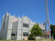
9 Ridge St South Perth
Cnr Ridge & Karoo St
Church Hall; St Mary's Church of the Virgin
St Mary's Close
South Perth
Metropolitan
Constructed from 1936, Constructed from 1931
| Type | Status | Date | Documents |
|---|---|---|---|
| Heritage List | Adopted | 14 Nov 2000 | |
| State Register | Registered | 31 Jul 2007 | HCWebsite.Listing+ListingDocument, HCWebsite.Listing+ListingDocument |
| Type | Status | Date | Documents |
|---|---|---|---|
| (no listings) |
| Type | Status | Date | Grading/Management | |
|---|---|---|---|---|
| Category | ||||
| Art Deco Significant Bldg Survey | Completed | 30 Jun 1994 | ||
| Anglican Church Inventory | YES | 31 Dec 1996 | ||
The place is generally in fair to good condition. There is evidence of some ongoing maintenance to the place, although this does not appear to be systematic or comprehensive. In particular, the Church has a number of cracks and rust is evident extenally. Ther are some damaged and missing glazing panes.
| Name | Type | Year From | Year To |
|---|---|---|---|
| Bruce Tomlinson - External cross | Architect | - | - |
| Hobbs, Winning & Leighton | Architect | - | - |
| William G Bennett, church hall | Architect | - | - |
| Herbert Parry, main church | Architect | - | - |
| Library Id | Title | Medium | Year Of Publication |
|---|---|---|---|
| 6752 | South Perth : the vanishing village. | Book | 2003 |
| 8523 | The church of Saint Mary the virgin, South Perth, Western Australia: conservation plan prepared for the Church Council. | Heritage Study {Cons'n Plan} | 2006 |
| 9733 | Church of St Mary the Virgin, 9 Ridge St, South Perth WA 6151 | Conservation works report | 2011 |
| 8792 | St Mary's Anglican Church, South Perth : report on facade and structure. | Heritage Study {Other} | 2007 |
| 7603 | By water and the word : a centennial history of the parish of St. Mary the Virgin, South Perth. | Book | 1998 |
Individual Building or Group
| Epoch | General | Specific |
|---|---|---|
| Original Use | RELIGIOUS | Church Hall |
| Other Use | RELIGIOUS | Church, Cathedral or Chapel |
| Present Use | RELIGIOUS | Church, Cathedral or Chapel |
| Style |
|---|
| Inter-War Gothic |
| Inter-War Functionalist |
| Type | General | Specific |
|---|---|---|
| Wall | CONCRETE | Reinforced Concrete |
| General | Specific |
|---|---|
| SOCIAL & CIVIC ACTIVITIES | Religion |
This information is provided voluntarily as a public service. The information provided is made available in good faith and is derived from sources believed to be reliable and accurate. However, the information is provided solely on the basis that readers will be responsible for making their own assessment of the matters discussed herein and are advised to verify all relevant representations, statements and information.
Constructed from 1931, Constructed from 1936
The following statement is drawn from the State Register Entry for Place 2385 St Mary’s Anglican Church Complex, prepared in 2007. St Mary’s Anglican Church Complex, comprising the Inter-War Gothic style Church (1931, 1950, 1958), the Inter-War Functionalist style former Hall (1936, 1956, 1993) the Statue of Christ (1970), and the Garden of Remembrance (1980) has cultural heritage significance for the following reasons: • the place is a landmark as a distinctive church building and tall monument located in a prominent position, clearly visible from many vantage points around Perth; • the Statue of Christ donated by Stanley Lovelock and designed by architect Bruce Tomlinson, is a fine example of a monument using stylised representation, distinguished by its height and prominence the Church is rare as a church constructed of reinforced concrete in the 1930s, and was reported in 1931 to be the first use of this construction method for a church in Western Australia; • the Church was designed by well-known Perth architect, George Herbert Parry, with additions and completion overseen by William T. Leighton, in accordance with Parry’s original concept; and, • the former Hall is a rare, though modest, example of an Inter-War Functionalist style hall in the Perth metropolitan area. The Parish Hall Complex (1993) and St Mary’s Close residential development (1993) have low significance. The Garden of Remembrance, has high value to relatives and friends of those memorialised there, and contributes to the cultural heritage significance of the place as a whole.
St Mary’s Anglican Church complex comprises the church (1931), church hall (fmr) (1936), Statue of Christ (1970), garden of Remembrance, the Parish Hall Complex and residential units of St Mary’s Close. The complex is located on a prominent elevated corner site on the rise of the highest hill in South Perth. It is located at the intersection of Ridge Street and Karoo Street and is surrounded by residential development. The Church is located on the corner of the lot with the Statue of Christ positioned in the garden adjacent to the church and the former Church Hall, now forming part of the associated St Mary’s Close residential development is to the south of the Church overlooking Ridge Street. St Mary’s Anglican Church has been constructed on an east-west axis, running parallel with Karoo Street. The changing topography around the church together with the massing of the church building and prominence of the monument combine to emphasise the presence of the church in the locality making it a local landmark. The Church is of reinforced concrete construction display design influences of the Inter-War Gothic style. The north and south elevations are divided into a series of bays creating a strong rhythm to the structure. Each bay is formed by buttresses and each contains four windows with tracery and leaded lights, each pane separated by concrete mullion. The placement of the windows creates a continuous glazed band throughout the middle of the elevations. The buttresses continue up above the roof line creating a pinnacle roofline. The top third of the north and south elevations is enlivened though mouldings, reflecting the pattern of the windows below. The lower section of the elevations contains four blank bays with centrally located decorative wall vents. The east end of the church is of similar presentation to the side elevations with the exception of there being two rows of windows. The verticality of the façade is emphasised by the buttresses and pinnacles, the parapet wall and the windows. The roof to the main body of the church is flat, obscured from view by the parapet walls. The north and south projecting wings, which present in the same manner as the east elevation, have obscured pitched and tiled roofs hidden by the parapet walls. The church is set within a simple landscaped setting to the north and east elevations with a more formal setting to the south incorporating a driveway providing access to the residential units and the former St Mary’s Hall. The new parish hall is constructed close to the west end of the church, connected by a covered walkway. The former St Mary’s Hall is a single storey brick and tile building with a rendered frontage of Inter-War Functionalist design, ‘streamline modern’, with curved walls divided into bands. The roof is hipped and tiled, part of which is obscured by the tall parapet to the main façade feature. “St Mary’s Hall” is inscribed on the pediment. The main façade element, is a rendered projecting bay with curved return walls divided into bands and three tall multi-paned windows to the Ridge Street frontage. Similar curved and banded walls form the entries into the two units. The monument, Statue of Christ, is a tall refined concrete tower in three sections, the bottom two each containing three piers and the top section being the cross. The monument sits high above the church and is thought to be over 30m in height contributing to its landmark status in the locality.
The growth of South Perth was slow until the 1880s, the discovery of gold in Western Australia from 1885 led to an increase in the population of Perth, with land facing Perth Water progressively sub-divided between 1886 and 1904. After the mid-1890s, a speculative element entered into the sale of South Perth suburban land. In 1892, the South Perth Roads Board District was formed, and, in 1902, the suburb became a municipality. By the turn of the century there were four jetties at South Perth, the Zoological Gardens had opened (in 1898), and a school and postal facilities were established. The first Anglican Church in South Perth was St Mary’s, a wooden building consecrated on 5 February 1899, on the corner of Onslow Street and Suburban Road (now Mill Point Road). Plans were made to acquire two blocks, one near Coode Street and the other near Mends Street, to move the church to one location, and build a mission hall on the other. Towards the end of October 1901, Anglican Bishop Riley dedicated the Holy Trinity Mission Hall in Douglas Avenue, South Perth. At the end of the same year, Bishop Riley returned to rededicate an enlarged St Mary’s Anglican Church, with a new sanctuary, on its new site in Labouchere Road, South Perth. Around 1919, the Holy Trinity Mission Hall was removed from its Douglas Avenue site and re-erected in the space behind St Mary’s Anglican Church in Labouchere Road. The Hall was now used for a Sunday School and a meeting place for the Ladies’ Guild and other groups. On 25 April 1929, a large group of Parishioners attended a meeting at St Mary’s to discuss a proposal to build a new Anglican church. Not long afterwards, the Rector of St Mary’s, John Bell, arranged the purchase of an acre of land on the corner of Karoo and Ridge Streets, on a prominent hill in South Perth. However, this site was unpopular with many parishioners, as they considered that the climb to the top of the hill was too physically demanding. Nonetheless, the plan to establish a church on the Karoo Street site was endorsed by the new Archbishop of Perth, Henry Le Fanu. In December 1930, planning for the new church, to be constructed of reinforced concrete, commenced, under the direction of the architect, George Herbert Parry. Parry (1882-1947) was born in Perth, the son of Anglican Bishop Parry. He was educated in Perth and later, in England. In 1911, Parry started his own practice. He had a particular interest in ecclesiastic work probably stemming from his family background, and subsequently designed many churches in Western Australia. Although reinforced concrete was a relatively cheap form of construction, the Parish only had sufficient funds to proceed with an initial section of the building. In March 1931, A.T. Brine and Sons’ tender of £2,333 was accepted for constructing the nave, a temporary sanctuary, two vestries, a porch to a height of 16 feet, and an elaborately detailed west end. Part of the expense was to be met by selling the Parish land on Labouchere Road. The foundation stone for the new church was laid on 3 May 1931 by the Governor of Western Australia, Sir William Campion, in the presence of Archbishop Le Fanu and Rector Bell.10 Seven months later, the church was consecrated over the two days of 7 and 8 November 1931, before a large crowd of 400 people in the church and 200 to 300 outside. The Parish Building Committee had wanted to relocate the old parish hall, which was the former St Mary’s Anglican Church from Labouchere Road beside the new church, but the South Perth Roads Board refused permission. In 1935, the church committee began planning for a parish hall and a rectory and, on 30 September 1936, the foundation stone for the Parish Hall was laid by (retired) Canon P.U. Henn. The completed Hall and Rectory were dedicated by the Archbishop on 5 November 1936. Construction was by W. Ralph and Son, with the project supervised by local parishioner and builder, E.W. Grigg, there being insufficient funds to engage an architect. It is likely that the St Mary’s Hall was, in fact, designed by William G. Bennett, then working with the architectural firm of Eales, Cohen and Bennett. During World War Two all works were put on hold the Parish Hall was blacked out. Furthermore, Roads Board workers dug trenches on the vacant land beside the Parish Hall, as a refuge for the congregation in the event of an air raid. On the occasion of the Victory in the Pacific celebrations in August 1945, the Rector of St Mary’s proposed that the chancel and the sanctuary of the Church should be completed as a memorial to those who had died in war. However, he did not pursue the matter further until 1950, when an appeal was launched to first clear the Church’s debt. In 1950, a new porch was built on the Church. The building work was carried out by parishioners working under the supervision of architect William T. Leighton, who lived nearby on Ridge Street, to a design in accordance with Parry’s original concept. This addition was dedicated by the Archbishop of 30 May 1950. In 1955, extensions to the Parish Hall were commenced. For a cost of £2,625, builder, Tom Lees erected the addition, and furniture, fittings and landscaping were provided. The extended Parish Hall was dedicated and renamed the Henn Memorial Hall by the Archbishop on 21 March 1956. Later in 1956, plans for the completion of the Church were made. In December of that year, sketch plans for the extensions to the Church prepared by William Leighton for architects, Hobbs, Winning and Leighton, of which he was a partner, were placed on display at St Mary’s. In September 1957, the winning tender of £16,550, from T.W. Lees and Sons, was accepted and work commenced. On 3 November 1957, 400 people gathered for the laying of the foundation stone by the Governor of Western Australia, Sir Charles Gairdner. On 13 July 1958, Assistant Bishop of Perth, Rev R.E. Freeth, consecrated and opened the additions. On 9 November 1958, Robert Moline, Archbishop of Perth, dedicated a War Memorial Chapel in the north transept. Flanking the Chapel Altar were two stained glass windows, one of St Mary and the other of St Mark. Later in the year, a third window, depicting St Francis, was installed. Already on the north wall was a window depicting St Cecilia, the Patron Saint of Music. In May 1968, a proposal was put forward by Stanley Lovelock, a retired farmer living nearby, that he would bequeath $20,000 to St Mary’s Anglican Church to build, during his lifetime, a monumental statue of Christ in the Church grounds. Apparently, Lovelock had been inspired by the statue of Christ overlooking and blessing Rio de Janeiro and wanted something similar for Perth. Parishioner Bruce Tomlinson, an architect and town-planner, was brought in to advise on the practicality of the project. Tomlinson designed a structure built of three slender columns of reinforced concrete, 300 feet high, and surmounted by a symbolic, rather than a figurative representation of Christ. After Tomlinson more accurately costed the idea and the support of the congregation was assured, the height of the proposed structure was reduced by half. While technical difficulties delayed construction at first, on 8 March 1970, Archbishop Sambell blessed the completed Statue of Christ. Restoration works were undertaken to the exterior and interior of the church during the early 1970s because of ongoing problems with the concrete construction. In 1979, money was donated to the Church to build a Garden of Remembrance, as a place for the ashes of cremated parishioners. In 1993, an aged care complex was constructed on the site which required the demolition of all buildings on the site except the church and church hall.
High / High
Good
| Name | Type | Year From | Year To |
|---|---|---|---|
| Herbert Parry (main Church) | Architect | - | - |
| William G Bennett (Church Hall) | Architect | - | - |
| Hobbs, Winning & Leighton | Architect | - | - |
| Bruce Tomlinson (external cross) | Architect | - | - |
| Ref ID No | Ref Name | Ref Source | Ref Date |
|---|---|---|---|
| Martin, GJ. "By Water and the Word: A Centennial History of the Parish of Saint Mary the Virgin, South Perth" | Curtin University of Technology Printing Services, Perth | 1998 |
| Reserve | Lot/Location | Plan/Diagram | Vol/Folio |
|---|---|---|---|
| 87 | 83901 | 1972-921 |
| Owner | Category |
|---|---|
| Perth Diocesan Trustees | Church Property |
This information is provided voluntarily as a public service. The information provided is made available in good faith and is derived from sources believed to be reliable and accurate. However, the information is provided solely on the basis that readers will be responsible for making their own assessment of the matters discussed herein and are advised to verify all relevant representations, statements and information.
16 York St South Perth
St Joseph's Convent
South Perth
Metropolitan
Constructed from 1890 to 1900
| Type | Status | Date | Documents |
|---|---|---|---|
| (no listings) |
| Type | Status | Date | Documents |
|---|---|---|---|
| (no listings) |
| Type | Status | Date | Grading/Management | |
|---|---|---|---|---|
| Category | ||||
| Municipal Inventory | Adopted | 14 Nov 2000 | Category A+ | |
02383 St Columba's Church Group & St Joseph's Convent, South Perth
| Name | Type | Year From | Year To |
|---|---|---|---|
| Richard Dennehy, orig owner | Architect | - | - |
Individual Building or Group
| Epoch | General | Specific |
|---|---|---|
| Present Use | RELIGIOUS | Housing or Quarters |
| Original Use | RESIDENTIAL | Two storey residence |
| Style |
|---|
| Federation Filigree |
| Type | General | Specific |
|---|---|---|
| Roof | TILE | Terracotta Tile |
| Wall | BRICK | Common Brick |
| General | Specific |
|---|---|
| SOCIAL & CIVIC ACTIVITIES | Religion |
This information is provided voluntarily as a public service. The information provided is made available in good faith and is derived from sources believed to be reliable and accurate. However, the information is provided solely on the basis that readers will be responsible for making their own assessment of the matters discussed herein and are advised to verify all relevant representations, statements and information.
Constructed from 1890, Constructed from 1900
Dennehy House - Saint Joseph’s Convent has aesthetic, historic, social, rarity and representative cultural heritage significance. It would have been an imposing residence in its time, which has been adapted over time to meet the needs of the Sisters of Saint Joseph. The Sisters first came to Western Australia in 1887 and have made a valuable social contribution since that time. The building is a fine representative example of a substantial Federation residence.
Dennehy House - Saint Joseph’s Convent is a substantial two-storey Federation building, with Filigree influences. The red brick building has a projecting wing, with a deep verandah across the rest of the building on both levels. The verandahs are supported by pairs of timber posts, adorned with timber lattice work and balustrading. Rendered, painted string coursing breaks the starkness of the red brick. The roof is tiled.
The Sisters of Saint Joseph first came to Western Australia in 1887, settling in Northampton. In January 1915, Sisters, led by Sr Padua Callinan, came to this site in South Perth. The principal building at Dennehy House - Saint Joseph’s Convent, now used as the Provincial offices, was originally known as Dennehy House. In 1914 the property was purchased by the Catholic Church for the sum of £3,000 from RJ Dennehy, an architect who specialised in religious architecture. He was also responsible for the Home of the Good Shepherd in West Leederville, built 1898, and the Church of the Sacred Heart in Leederville, built 1905.
Moderate-High
Good
| Ref ID No | Ref Name | Ref Source | Ref Date |
|---|---|---|---|
| Florey, Cecil. "Peninsular City: A Social History of the City of South Perth" |
This information is provided voluntarily as a public service. The information provided is made available in good faith and is derived from sources believed to be reliable and accurate. However, the information is provided solely on the basis that readers will be responsible for making their own assessment of the matters discussed herein and are advised to verify all relevant representations, statements and information.
30 York St South Perth
South Perth
Metropolitan
Constructed from 1908
| Type | Status | Date | Documents |
|---|---|---|---|
| (no listings) |
| Type | Status | Date | Documents |
|---|---|---|---|
| (no listings) |
| Type | Status | Date | Grading/Management | |
|---|---|---|---|---|
| Category | ||||
| Municipal Inventory | Adopted | 14 Nov 2000 | Category A+ | |
02383 St Columba's Church Group & St Joseph's Convent, South Perth
| Name | Type | Year From | Year To |
|---|---|---|---|
| Richard Joseph Dennehy | Architect | - | - |
Individual Building or Group
| Epoch | General | Specific |
|---|---|---|
| Original Use | EDUCATIONAL | Primary School |
| Present Use | EDUCATIONAL | Primary School |
This information is provided voluntarily as a public service. The information provided is made available in good faith and is derived from sources believed to be reliable and accurate. However, the information is provided solely on the basis that readers will be responsible for making their own assessment of the matters discussed herein and are advised to verify all relevant representations, statements and information.
Constructed from 1908
Saint Columba’s Primary School has aesthetic, historic, social and representative cultural heritage significance. The school has a long history in the Catholic community of South Perth that started with a simple combined church and school hall in 1908. The hall was still used as part of the school in 1999. Saint Columba’s Primary School is the parish school linked to the nearby Saint Columba’s Catholic Church which was built in 1936.
Saint Columba’s Primary School is made up of a series of buildings constructed in different time periods. The original Federation buildings have been extended over time, with inter-war and post war influences evident. The Pre-Primary building is a modern construction built in 1990. Some of the buildings retain the original facebrick finish, while other buildings have been rendered and painted.
The first building on the site of the present Saint Columba’s Primary School was completed in 1908. The original teachers at the school were the Sisters of Mercy, followed by the Sisters of Saint Joseph of the Sacred Heart who established themselves in the convent in York Street in 1915. (Refer Pl No. SPCnt 1-Dennehy House). The school was then called Mount Saint Joseph’s, but changed its name to Saint Columba’s Primary School in 1938, three years after the parish Church of the same name was built. (Refer Pl No. SPCnt 7a - Saint Columba’s Church). The school remained under the principalship of the sisters for seven decades before the first lay principal was appointed in 1986. Saint Columba’s Primary School celebrated its 91st Birthday in 1999. At that time there were 235 students. The principal was Ms Loretta Gibson and the school was served by all lay staff members.
Moderate
Good
| Name | Type | Year From | Year To |
|---|---|---|---|
| Richard Joseph Dennehy | Architect | - | - |
| Ref ID No | Ref Name | Ref Source | Ref Date |
|---|---|---|---|
| Florey, Cecil. "Peninsular City: A Social History of the City of South Perth" | City of South Perth | 1995 |
| Owner | Category |
|---|---|
| Roman Catholic Archbishop of Perth | Church Property |
This information is provided voluntarily as a public service. The information provided is made available in good faith and is derived from sources believed to be reliable and accurate. However, the information is provided solely on the basis that readers will be responsible for making their own assessment of the matters discussed herein and are advised to verify all relevant representations, statements and information.
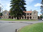
295 Manning Rd Waterford
30/9/2011 Address includes: Lot 9001 Manning Road, Waterford. VFL.
Clontarf Boys Town
Clontarf Campus
St Joseph's Boys Orphanage
South Perth
Metropolitan
Constructed from 1901 to 1999
| Type | Status | Date | Documents |
|---|---|---|---|
| Heritage List | Adopted | 14 Nov 2000 | |
| Heritage Agreement | YES | 27 Jun 2011 | HCWebsite.Listing+ListingDocument |
| State Register | Registered | 14 Dec 2001 | HCWebsite.Listing+ListingDocument, HCWebsite.Listing+ListingDocument |
| Type | Status | Date | Documents |
|---|---|---|---|
| (no listings) |
| Type | Status | Date | Grading/Management | |
|---|---|---|---|---|
| Category | ||||
| Art Deco Significant Bldg Survey | Completed | 30 Jun 1994 | ||
| Classified by the National Trust | Classified | 08 Jul 2002 | ||
| Name | Type | Year From | Year To |
|---|---|---|---|
| Marie Jackson - Chapel | Architect | - | - |
| Michael Cavanagh | Architect | - | - |
| Howard, Bonner & Tracey | Architect | - | - |
| E Le B Henderson | Architect | - | - |
| Library Id | Title | Medium | Year Of Publication |
|---|---|---|---|
| 8707 | Clontarf campus former gymnasium : archival record. | Archival Record | 2007 |
| 4681 | Photographic extracts from : Clontarf management plan draft report : prepared by Allom Lovell Hocking conservation consultants for Provincialate of Christian Brothers : with funding from the Lotteries Commission : October 1998. | Report | 1998 |
| 9408 | Marr Mooditj Foundation - Stage 2: Classroom and administration building. | Heritage Study {Other} | 2009 |
| 11775 | Clontarf Place management & masterplan recommendations FINAL | Heritage Study {Other} | 2016 |
| 4233 | Clontarf Conservation Management Plan : draft report : volumes 1 and 2. | Heritage Study {Cons'n Plan} | 1998 |
| 5186 | Former Technical Trades Building, Clontarf, Western Australia : conservation works report. | Heritage Study {Other} | 2001 |
| 5124 | Clontarf : conservation management plan : draft report / prepared by Allom Lovell Hocking Conservation Consultants for Provincialate of Christian Brothers. | Heritage Study {Other} | 1998 |
| 9466 | Signposts: a guide for children and young people in care in WA from 1920. | Electronic | 2010 |
Individual Building or Group
| Epoch | General | Specific |
|---|---|---|
| Other Use | GOVERNMENTAL | Other |
| Original Use | RESIDENTIAL | Institutional Housing |
| Present Use | EDUCATIONAL | Combined School |
| Original Use | EDUCATIONAL | Combined School |
| Other Use | RELIGIOUS | Church, Cathedral or Chapel |
| Style |
|---|
| Victorian Romanesque |
| Inter-War Romanesque |
| Type | General | Specific |
|---|---|---|
| Wall | STONE | Limestone |
| Wall | BRICK | Rendered Brick |
| Wall | BRICK | Common Brick |
| General | Specific |
|---|---|
| SOCIAL & CIVIC ACTIVITIES | Institutions |
This information is provided voluntarily as a public service. The information provided is made available in good faith and is derived from sources believed to be reliable and accurate. However, the information is provided solely on the basis that readers will be responsible for making their own assessment of the matters discussed herein and are advised to verify all relevant representations, statements and information.
Constructed from 1901
The following statement is taken from the Register Entry for Place 2401 Clontarf prepared by the State Heritage Office in 2001. Clontarf, a large site containing buildings of a former orphanage, farm and school dating from 1901 to 1973 in a variety of styles, some later buildings, ‘Brother Keaney’s Gardens’, sports grounds, swimming pool, gardens and wetlands, has cultural heritage significance for the following reasons: • the place is important for its schooling of day boys and boarders, residential care education and supervision of orphans, vagrants, children from suffering families, child migrants and Aboriginal children from 1901 to the 1980s. It represents memories and associations for those in whose lives it played an important role and is a tangible reminder of the institutionalisation, abuse and exploitation suffered by some boys at the hands of those charged with their care; • the buildings constructed in the period 1935-41 (including the clock tower) are examples of the technical achievements of the Christian Brothers and the children who worked under their supervision; • the elegant proportions and fine interior detailing of the Inter-War Romanesque style chapel is of aesthetic value and demonstrates the level of technical excellence achieved by the boys and Brothers through the progressive construction process on the site; • the main building is a fine example of Victorian Romanesque style by Architect Michael Cavanagh, constructed in local limestone with soft red brick detailing; • the chapel is associated with architect Marie Jackson; • is valued by the Christian Brothers as a demonstration of the organisation’s philanthropic educational basis; • is valued by the Aboriginal community of Perth and Western Australia as a place of education and self-determination integral to the formation of their modern culture; • is of aesthetic value for its formal entry statements, driveway, mature trees, rose gardens, expansive lawns, wetlands and homogenous group of pale walled, terracotta roofed buildings; and, the site has landmark qualities and contributes to the community’s sense of place.
Clontarf is located on the southern side of Manning Road adjacent to the Canning River. The site presents as a collection of buildings of assorted design, style and purpose, arranged around the centrepiece of the original 1901 building, central driveway and adjacent lawn areas. The site is unified by a number of similar wall/gate features containing semicircular entry statements, tall pillars and/or low machicolated or solid walls constructed in smooth or roughcast rendered painted brickwork. The site also features a number of statues and memorials including a statue of Christian Brothers’ founder Edmund Rice located north of the Brothers’ residence and statues of the Virgin Mary and St Joseph located in the central lawn area. Other structures in the grounds include an electrical substation, clock tower, handball courts, swimming pool, basketball courts and retaining walls. Brothers’ Residence (1985) This building is located in the gardens on the eastern side of the main driveway. It originally provided four bedrooms and shared living areas for the brothers but was extended in 1991 to provide a further self contained flat at the northern end, connected to the original building by a covered walkway. Former Presbytery/Chaplain’s Residence (1936; 1973) This residence is located on the eastern side of the central driveway between the Chapel and the Brother’s Residence. The former Presbytery is a brick bungalow with a hipped terracotta tiled roof. Chapel (1940-41; 1972; 1974-78) The chapel is located to the north-east of the main building on the eastern side of the central driveway. It replaced an earlier chapel located in the main building. The chapel is an Inter-War Romanesque styled rendered brick building with a terracotta tiled roof concealed behind parapet gables on the north and south ends. All windows and doors are set in round arched openings accentuated by a rendered hood mould detail on the surrounding wall. The windows are leadlight and the doors are in diagonal set v-jointed boarding. Library (1974-75) The Library in located at the south-east corner of the main building. It was constructed as a library and science block and is currently used by Clontarf Aboriginal College as a library and computer room. The Library is a long rectangular concrete block building with a tiled gable roof. Pre-cast concrete box gutters obscure the eaves on the north and south elevations. The doors and windows are aluminium framed. Gymnasium (former) (1938; 1957; 1962) The Gymnasium is located at the south-east corner of the site on the edge of the embankment leading down to the foreshore and the adjacent wetlands. It was constructed as a mechanics workshop and changed to a Gymnasium in 1957 which involved bricking in of the lower part of windows and alterations to doorways. The timber floor was added in 1962. Former Technical Trades Building (1935-37) This building is located to the south-east of the main building, south of the Library and west of the former Gymnasium. It was constructed in stages from 1935-37. The north-eastern and southern wings of the building were demolished in late 1999 and conservation works carried out on the remaining portion including the original water tower and classroom/dormitory. Main Building (1901; 1939-40; 1947; 1972) The main building is located at the termination of the central driveway. It was constructed in 1901 as the St Joseph’s Orphanage. This two-storey Victorian Romanesque style rusticated limestone building has a terracotta-tiled roof set behind parapet gables. It has a symmetrical façade with arcaded verandahs at first and second floor in between the gable ends. The building has brick detailing around windows, doors, elliptical arches of the ground floor arcade, first floor verandah balustrade, string-courses and chimneys. Some of the brick detail has been rendered over. The building is basically u-shaped and a two-storey verandah surrounds a central courtyard at the rear of the building and extends across the southern faces of the two side wings. Original windows are double hung timber sashes with a central glazing bead. Some have been replaced with aluminium frames. Original doors are multi-paneled in solid timber or half-glazed French doors. Some of these have also been replaced with flush panel doors or filled with aluminium framed windows with solid base panels. Classroom Block (1937-38; c1961; 1964) The classroom block is located to the south-west of the main building on the edge of the embankment which leads down to the sports ground. It was constructed in 1937-38 to provide classrooms, library and handball court. By 1961, verandah piers had been replaced and the handball court was converted to a squash court in 1964. The building is constructed of rendered and face-brick and has a hipped tiled roof. In plan the building is essentially U-shaped with the long axis being in the centre of the “U” and extending along an east-west axis. A tower is located centrally along this axis. The tower has a hipped tiled roof and concrete cantilever balconies projecting to the east and west. Keaney Memorial Hall, former shower block and toilets (Recreation Hall) (c.1927; 1938; 1940; 1954; 1960; 1963) The Recreation Hall is located on the western side of the main building. The Hall, which was originally timber framed with an iron roof, was apparently brought to the site from Mundaring Weir c.1927. The toilet block to the west of the hall was constructed in 1938. The shower block is probably that constructed in 1929 also referred to as a bathroom block. In 1940, the walls of the hall were replaced with brick and in 1951, the shower block was converted into a locker room. In 1954, a new brick façade was added to the east elevation, an additional set of double doors were added to the south elevation and a tuck-shop installed at the eastern end of the hall. The former shower block was renovated in 1960 and the toilet block in 1987. A roof was also constructed to join the three buildings in 1963. Garage/work shop (1958; 1998) The workshop is located on the south side of the east-west driveway, southwest of the former Dining Room/Kitchen. The workshop consists of a rendered brick building with a low pitched steel roof set behind a small parapet on the western end of the northern elevation. Former Kitchen and Dining Room (1939-40; 1949-50; 1951; 1957; 1969) This building is located at south-west corner of the central lawn area, at the junction of the western secondary driveway and the road which runs eastwest across the front of the main building. It originally contained dining rooms from the boys and Brothers, a kitchen, storerooms and cool rooms. A tower on the south-west corner was removed and the ceilings and floor replaced in the boys dining room in 1949-50. In 1951 the Brothers dining room was renovated and a new cool room installed and in 1957 the kitchen was renovated. The front of the building was tuckpointed in 1969. Former Matron’s Residence and former Laundry (Noolbenger) (1952; 1962) These buildings are located on the western side of the central lawn area adjacent to the secondary driveway between the former Kitchen/dining room and Jackson House. The laundry was constructed in 1952 and the residence in 1962. Jackson House (Abmusic) (c.1942) This building is also located on the western side of the central lawn area adjacent to the secondary driveway. It was brought to the site by the RAAF during World War II and was since used as a convent (c1948-1966), hostel (1966-81), MS Society (1981-86) and Abmusic College (1986-1999). Abmusic Building (1998-9) Located at the north-western corner of the site and having its main entry facing south, this is a collection of five single-storey buildings surrounding a central courtyard connected by covered walkways and verandahs, purpose built for the Aboriginal and Islander College of Music. The building is constructed in rendered brickwork and has a curved Colorbond steel roof and Aluminium framed windows. Salvaged pine power poles have been used to support undulating verandahs and walkways. This building is in excellent condition.
The following information is largely drawn from the assessment documentation prepared for the inclusion of the place in the State Register of Heritage Places in 2001. In 1802, the Christian Brothers’ organisation (the Brothers) was founded by Edmund Rice in Waterford, Ireland, to educate poor boys, this later developed to the institutional care of orphans. In 1868, the Brothers first arrived in eastern Australia, and then, in 1894, they came to Western Australia. On 23 November 1897, the Brothers assumed management of St Joseph’s boys’ orphanage in Subiaco, which had been established in 1872 by the Sisters of Mercy. In 1897, Canning Location 87 and Canning Locations 57 and 65 were purchased for a new orphanage. The land was on the north bank of the Canning River and was uncleared bushland with a fresh water spring. The site was named Clontarf by Brother Treacy, the leaders of the brothers in Australia after a town in Ireland, and it was to be a place where boys could be accommodated and cared for, given primary education, religious teaching and receive basic training in manual skills and farm practices. By 1900, plans were under way for the construction of the main building at Clontarf. The architect, Michael Francis Cavanagh, was commissioned to design the buildings and the building contract was awarded to Mr J. Coghill for the cost of £8500. Cavanagh, originally from Victoria, had been practicing in Western Australia since 1895 and had designed several other Catholic institutions. Limestone and other materials used in the construction were shipped up the Canning River, but were off-loaded on the south side of the river due to the location of a small channel. A jetty was therefore extended most of the way across the river and a small rail-line was installed to move the stone on trolleys pulled by mules. On 3 January 1901 the foundation stone of the main building was laid by the Most Reverend Matthew Gibney D. D., Lord Bishop of Perth. Although the site was named Clontarf, the actual orphanage was named St Joseph’s Boys’ Orphanage after the orphanage in Subiaco. On 8 September 1901, the main building, which included a chapel, had been completed and was ready for occupation. The boys from St Joseph’s, Subiaco, were relocated to Clontarf. At the time of its establishment, the boys who resided at Clontarf were predominantly aged between six and fourteen. The boys were either orphans, or abandoned or had one parent (usually the mother) who was unable to support them. In its first few years, there were between 100 to 150 boys based at Clontarf under the care of five or six Brothers. After the age of fourteen, most boys left to either find work and/or return to their family. Those who did stay on - because of lack of any other opportunity - assisted the Brothers in the day-to-day running of the institution, but no longer attended school. In 1903, sports grounds for cricket and football were established between the main buildings and the river, as well as a jetty and boat shed. Additional recreation space was later provided by reclaimed swampland. In 1908, the Brothers purchased a further 28 acres of land to the east of the Clontarf site, comprising Lots 80, 81, 82 and 83. In 1914, a statue of St Joseph was placed in the grounds in front of the main building. In 1918, a bandstand was constructed as a performance venue for Clontarf’s newly formed brass band. In 1919, a manual arts block for carpentry and boot-making was erected to the south-east of the main building. In 1921, Lots 16 and 17 to the west were purchased. By the early 1920s, Clontarf was a fully operational farm with orchards and vegetable gardens at the north-eastern end of the site, cultivated and tended by the boys. There was also a dairy, a poultry yard, piggery and stock runs. As a result, Clontarf was near self-sufficient. The grounds were fenced with post and rail fences, and picket fences all painted white. A number of outbuildings (most of which are no longer extant) had been constructed including a bakehouse, laundry, toilets, storerooms and a water tower. Some time between 1926 and 1929, an area now referred to as ‘Brother Keaney’s Garden’ was established, and this included a lake surrounded by palm trees. Brother Keaney was the Superior of Clontarf for two terms until 1942. In a 1927 report, the Recreation Hall is first mentioned. This timber and iron hall was relocated from Mundaring Weir to Clontarf and erected south-west of the main building. In addition to general recreational activities, it was used as a gymnasium and had a stage at one end for presentations and performances, and later as a cinema. In 1940, the timber walls were replaced with brick. Also in 1927, hot showers were introduced to the home. In 1929, a bathroom block was added to the south-west of the main building. In 1929, a grotto to honour Our Lady of Lourdes was constructed on the slope towards the Canning River. In 1954, this was moved to the south of the Chapel to make way for handball courts. The grave of student Michael Bowman, who was killed in a bus accident in 1955, is located behind the grotto. By the late 1920s, a matron had been employed at Clontarf, and her quarters were located in a small building to the west of the main building. Circa 1935, a small dormitory with a water tower - containing a concrete water tank - was built, south of the manual arts building. This was extended in 1937, originally for classrooms, but becoming the Technical Trades Block. All brick work and most of the carpentry was done by the boys. From 1936, under the direction of Supervisor Brother Paul Keaney, Clontarf underwent probably its greatest phase of development to date both in the construction of further accommodation and facilities, as well as in the training schemes for the resident boys. In order to achieve this, Brother Keaney attracted generous donations of money, materials and services, as well as substantial Lotteries Commission grants. In addition, c.1936, Locations 14 and 15 were purchased, extending Clontarf’s boundaries further westward, and 90 acres were purchased to the east. In 1936, the Chaplain’s Residence was built on the east of the entrance avenue. In 1937, the British child migrant scheme began but it was not until August 1938 that the first boys went to Christian Brothers’ homes in Western Australia. The boys went to Clontarf, Bindoon and Castledare. By 1938, enrolments at Clontarf had increased to 208. To accommodate the extra boys, a new classroom block was built, officially opening on 20 March 1938. This new block was designed by architects Howard, Bonner and Tracey and included a tower with small balconies, a library with a large fireplace in the western room, and a large handball court and later (1940) a tennis court. Other works completed in the period 1938 to 1940 include a toilet block and a mechanics’ workshop, a bakehouse which included a clock tower, flour mill, laundry and servants’ quarters, new entrance gates at the Manning Road end, and a pavilion on the oval (north). In 1940, the dining and kitchen block was completed, containing the boys’ dining room, Brothers’ refectory, kitchen, refrigeration and storerooms Originally the building had two towers, but only the north-west tower remains. In 1939-40, the timber verandahs were removed from the rear of the main building and replaced with concrete walled and jarrah floored verandahs on all but the north side of the building. Towers were also added at this time on the south-west and south-east corners, possibly being used as bedrooms for the older boys. In 1940, a two-storey annex was added to the western side of the main building, resulting in the loss of the former matron’s quarters. This annexe was later demolished. At the end of 1940, foundations were laid for the much needed larger chapel, designed by architect, Marie Jackson. The majority of building works were carried out by Clontarf boys and Brothers. The rose window was apparently designed and manufactured in Ireland, and the original bell was a personal gift of the Archbishop. On 20 December 1941, the new chapel was consecrated, with an official opening ceremony held the following day. It was at this ceremony that the name ‘Clontarf Boys’ Town’ was suggested. During the Second World War, on 1 March 1942, the RAAF took occupation of Clontarf. The Brothers and boys were relocated to the farms at Bindoon and Tardun. On 1 February 1945, the RAAF moved out. Although some buildings were added to the site by the RAAF during its occupation, much furniture and equipment belonging to Clontarf has been either lost or destroyed, and the farm and grounds had become neglected. Upon returning to Clontarf, the Brothers and the boys set about bringing the institution back to what it was before the war. In 1947, the main building was extensively renovated. Other works carried out after the War included the renovation and upgrade of the Dining and Kitchen block (1949-50), the reopening of the bakery (1948), reinstatement of partitions in the classroom block (1951) and re-equipping of the Technical block (1951-52). In 1949, an outdoor stage/auditorium designed by the architect, Edgar Henderson, was erected in the quadrangle. Some of the former RAAF buildings left on site were utilised by the Brothers after the War, and the remainder were progressively demolished. Some of the former RAAF buildings left on site were utilised by the Brothers after the War, and the remainder were progressively demolished. Works to the grounds and gardens and the farm were also carried out in the period immediately after the War. The palms along the entrance avenue and in front of the main building were replaced with roses and other flowering shrubs. In 1950, the quadrangle was cemented and a picket fence erected from the rear of the quadrangle to the convent. The farm was brought back to its pre-War state with clearing and fencing as well as improvements to the building and the building of a new dairy (1951). In 1952, the artist Antony Paraphilaekos [sic] was commissioned to paint a mural of the crucifixion on the dome of the sanctuary. After the War the Education Department reorganised and increased provision of secondary education in line with developments in other countries - particularly Britain. This meant that many of the boys were able to sit for their Junior Certificate at Clontarf, which previously had been undertaken at nearby Aquinas College. Some also went on to complete their Leaving at Aquinas while still residing at Clontarf. In addition, there was an influx of British and Maltese migrants from the late 1940s early 1950s. These two events resulted in an increase in residential numbers, which peaked at 249 in 1953. In 1954, following the death of Brother Keaney, the recreation hall underwent a major renovation, including a new brick facade, and was renamed the Keaney Memorial Hall. In 1957, another memorial was established in honour of the founder of the Christian Brothers - Brother Edmund Rice. A garden, including a statue of Brother Rice, a rose garden and a pond, was developed between the presbytery and Manning Road. Between 1957 and 1958 several works occurred. In 1957, the former mechanics’ workshop was renovated and converted into a gymnasium. In 1958, a new garage was built. On 7 March 1958, the first swimming pool was opened at Clontarf. Between 1957 and 1958 several works occurred. In 1957, the former mechanics’ workshop was renovated and converted into a gymnasium. In 1958, a new garage was built. On 7 March 1958, the first swimming pool was opened at Clontarf. The 1960s saw the beginning of the selling off of Clontarf land by the Brothers. In 1966, the Sisters vacated their convent, which was then renovated and turned into a hostel, named Jackson House. The hostel was used by both WAIT (now Curtin University) students and senior boys. The 1970s were a transition period for Clontarf. In 1973, it was announced that Clontarf was to move toward becoming a treatment centre for adolescents with problems. From 1977, very few day boys were enrolled, and by the 1980s, the number of resident boys had more than halved. The chapel also underwent several changes during the 1970s. In 1972, two stained glass panels from the original chapel in the main building were incorporated into the chapel doors, and between 1974-1978, the original chapel windows were replaced with five new stained windows. Circa 1974, the manual arts building was demolished to make way for the new science and library building. This building, designed by Henderson and Thompson, was completed in 1975. In the late 1980s, allegations of sexual and physical abuse and exploitation were made against the Christian Brothers by former students/residents of their institutions. An organisation named ‘Voices’ was established by former students/residents to represent and provide counselling for those who had experienced abuse at the Christian Brothers’ orphanages. The Christian Brothers accepted that there was strong evidence that many of the allegations were true, and made a public apology. The existence of many of the buildings at Christian Brothers institutions built by staff and children under their supervision is a tangible reminder of the perceived exploitation of the former residents. In 1983, the treatment Centre for Adolescents closed which prompted two years of study and community consultation, which led to the decision to reopen, a school for Aboriginal youths aged 15 to 18. On 2 May 1986, Clontarf Aboriginal College was officially opened in the main building. Aboriginal children from all over the state attended the College. With increased use by the Aboriginal community generally, many fledgling Aboriginal organisations were offered low cost rental arrangements to utilise other buildings on the site. The Brothers retained the use of the chapel and their two residences. On 22 April 2013, after more than a decade of negotiations, the ownership of the 12.3 hectare Clontarf campus passed to the Indigenous Land Corporation in the form of a $26 million gift that had to be approved by the Vatican. Clontarf Aboriginal College continues [2018] to operate at the site and develop its programs for Aboriginal boys and girls from all regions of the state.
Moderate / Moderate
Good
| Name | Type | Year From | Year To |
|---|---|---|---|
| Michael Cavanagh | Architect | - | - |
| Howards | Architect | - | - |
| E Le B Henderson | Architect | - | - |
| Ref ID No | Ref Name | Ref Source | Ref Date |
|---|---|---|---|
| Apperly, R. Irving, R. Reynolds, P. "A Pictorial Guide to Identifying Australian Architecture" | Angus and Robertson NSW | 1989 | |
| Molyneux, I. "Looking Around Perth: A Guide to the Architecture of Perth & Surrounding Towns" | Royal Institute of Architects | 1981 |
| Reserve | Lot/Location | Plan/Diagram | Vol/Folio |
|---|---|---|---|
| 500 | 70746 | 2781-431 |
This information is provided voluntarily as a public service. The information provided is made available in good faith and is derived from sources believed to be reliable and accurate. However, the information is provided solely on the basis that readers will be responsible for making their own assessment of the matters discussed herein and are advised to verify all relevant representations, statements and information.